Post-catastrophe Aerial Imagery Is Instrumental for Insurers
Within days following catastrophic events, aerial imagery company Nearmap provides property and casualty insurance carriers in the USA with high-resolution aerial captures.
Combined with accelerated delivery times from Nearmap, the frequency, immediacy and consistent quality of the imagery offered provides a clear view into property damage, even in complex instances that require careful inspection. This allows insurers to determine the extent of damage and decide how to allocate loss adjusters to impacted properties.
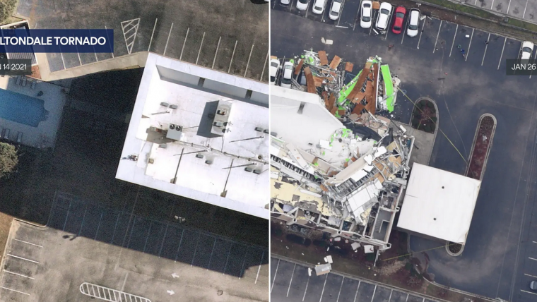
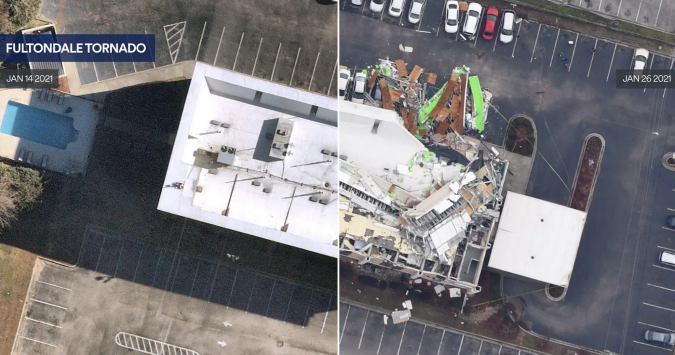
Post-catastrophe imagery of tornadoes, hurricanes and wildfires
“Insurers can rely on Nearmap’s high-resolution, patented aerial sensors, capture expertise and rapid processing capabilities to get urgent property details online to help carriers get their customers back on their feet quickly,” said Patrick Quigley, executive vice president and general manager of the insurance practice at Nearmap.
2020 was a record-breaking disaster season in the USA and Nearmap captured post-catastrophe (post-cat) imagery of more than 20 events including tornadoes, hurricanes, wildfires, severe wind events and civil unrest. In 2021, Nearmap is expanding the programme to meet increased demand by companies to equip their claims teams with the best available insurance property data in the face of rising cat losses.
“While each major event has unique impacts, aerial imagery provides the ability to rapidly review and understand those consequences with meaningful benefit for those most affected,” continued Quigley. “We realize the important role our post-cat images play when disaster strikes and are committed to leading the innovation in this space to provide more informed and efficient claims processing to foster quick deployment of critical resources in 2021.”
Outside of the post-cat programme, the Nearmap regular capture footprint covers 90.1 million total parcels comprised of residential, commercial and other properties in the USA, up to three times per year. This library of images dating back to 2014 makes it easy for insurers to understand property changes over time. Together, with its pre-event and post-cat content, Nearmap provides a set of high-resolution data that’s unavailable anywhere else to help insurers quickly assess and respond to major events as they occur.

Value staying current with geomatics?
Stay on the map with our expertly curated newsletters.
We provide educational insights, industry updates, and inspiring stories to help you learn, grow, and reach your full potential in your field. Don't miss out - subscribe today and ensure you're always informed, educated, and inspired.
Choose your newsletter(s)


