Precision Agriculture Meets UAV Technology with Pix4Dmapper
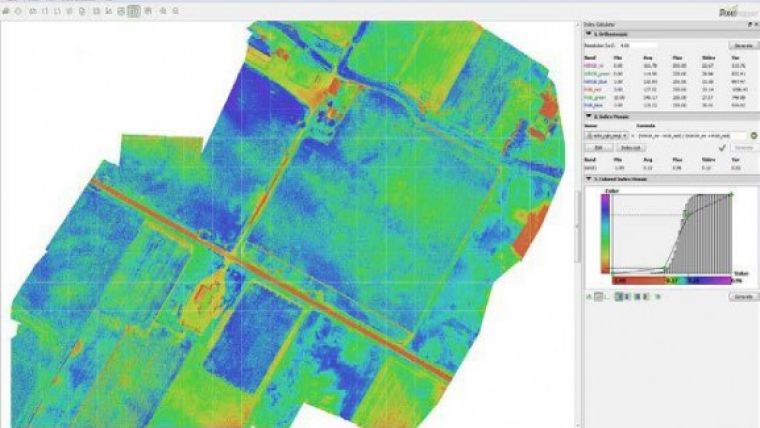
Pix4D, the Swiss provider of UAV processing software, has released version 1.1 of Pix4Dmapper. The new version includes additional features for precision agriculture as well as support for all GoPro models. The integrated Index Calculator allows users to create meaningful maps from any multi-spectral sensor and customise their NDVIs and any vegetation index map directly in the software.
How to get from UAV imagery to NDVIs in a single workflow and just a few clicks? It all starts with using either multi-spectral sensors or more than one camera, for example processing NIR and RGB imagery together in one project. Once the images are processed, the newly integrated Index Calculator will let users do the rest in a few simple clicks. After setting or editing the map resolution, users can choose from pre-defined formulas to generate single-band and index maps or create and save their own formulas. Results can then be customised by editing colour classes and gradients to create index maps with the most appropriate colour scheme.
New applications
This new feature will open up countless new applications for UAV imagery, not only in precision agriculture but any field requiring an user-friendly and fully integrated solution to generate meaningful maps out of multi-spectral sensors.
In addition to the Index Calculator, Pix4Dmapper’s Version 1.1 provides full support for all GoPro models and lenses, including the Fisheye lens, removing GoPro lens distortion automatically. Imagery can be acquired both from the ground or the air using any UAV, opening up a whole new world of modelling possibilities. Version 1.1 also includes more and improved rayCloud features for project re-optimisation, filter creation based on image content, contour line creation and improved object annotation to mention just the most important.
To get the most out of Pix4Dmapper, Pix4D organises User workshops (both for beginners and advanced users) again this year. The first workshops will take place in early July in Lausanne, Switzerland. In addition, Pix4D has introduced monthly webinars to offer shorter and more targeted training sessions. Detailed programmes and registration for both webinars and workshops are available on Pix4D’s website under www.pix4d.com/workshops.
Pix4Dmapper is available both as a one-time charge licence and a monthly or yearly subscription model.

Value staying current with geomatics?
Stay on the map with our expertly curated newsletters.
We provide educational insights, industry updates, and inspiring stories to help you learn, grow, and reach your full potential in your field. Don't miss out - subscribe today and ensure you're always informed, educated, and inspired.
Choose your newsletter(s)


