Predicting Fire Risk with UAV Lidar
A forest fire site has been assessed using both high-resolution Lidar captured from a drone and satellite optical imagery to appraise the potential of this approach for the future. After all, forest fires are becoming more common due to climate change and causing ecological and economic loss. The findings showed that UAV Lidar data provided ecologically meaningful metrics which can be used to predict fire risk, develop more precise, site-specific fire impact studies and create post-fire management plans.
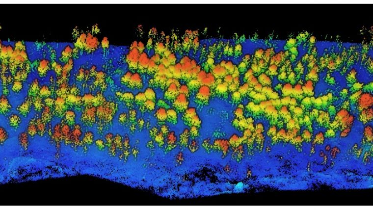
Wildfires do not burn evenly through forests, some areas may be barely touched, whilst in other areas, most of the trees and foliage will be severely damaged. Understanding the severity and distribution of a fire within a forest can assist with estimating and modeling future forest fires to aid both prevention and containment.
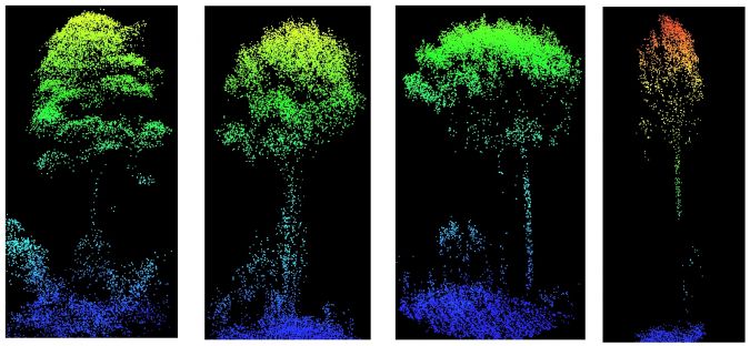
Satellite optical imagery is not able to penetrate through the canopy down to the low-level vegetation and the ground below. Low altitude UAV Lidar overcomes this constraint. Lasers can penetrate through the gaps in the foliage and the resulting 3-dimensional point cloud displays the canopy, the lower vegetation and the ground beneath. Individual trees can be detected and the vertical profile of the canopy and vegetation can be viewed.
Canopy height models
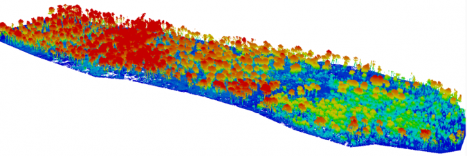
In this study, the research team at Toledo University surveyed the 2017 Yeste forest fire site in the province of Albacete, southeast Spain. The survey was undertaken using the Routescene UAV Lidar system and data analysis in Routescene's LidarViewer Pro software to establish ground from non-ground points to then created digital terrain models (DTMs) and canopy height models.
Relatively few studies have used Lidar drone data to characterize crown damage after fires at the individual tree level. The team could distinguish crown fire from surface fire through changes in the understory Leaf Area Index and understory and midstory vegetation. They found that unburned and low-severity burned areas were more diverse in tree structures than moderate and high severity burned ones.
Distinguishing post-fire plant structures with UAV Lidar data
Olga Viedma from the Department of Environmental Sciences, University of Castilla-La Mancha, Spain, commented: “UAV Lidar surveying, with its level of detail, was the obvious next choice of technology and a natural evolution to further examine the levels of damage to individual trees. I am delighted to say the Routescene UAV Lidar system worked well and proved to be very useful. We have since carried out further studies on forest fires using the system in central Spain and the Canary Islands.”
The project demonstrated the potential to distinguish post-fire plant structures in detail using UAV Lidar data. When crossed with satellite-based fire severity metrics, the high resolution results allow researchers to estimate the impact of fire on single trees not just whole forested areas, using metrics that are ecologically meaningful down to an individual tree level.
For more information on this case study of the Routescene UAV Lidar system being used for investigating the effects of forest fires, see here.

Value staying current with geomatics?
Stay on the map with our expertly curated newsletters.
We provide educational insights, industry updates, and inspiring stories to help you learn, grow, and reach your full potential in your field. Don't miss out - subscribe today and ensure you're always informed, educated, and inspired.
Choose your newsletter(s)


