Revolutionizing planetary exploration: AI-assisted mapping
Can we leave the mapping of the planets and moons in our solar system to AI-powered systems? The answer seems to be ‘yes’, as scientists have now developed a novel, open-source approach for the mapping of planetary landforms using artificial intelligence (AI). This approach uses deep-learning techniques and artificial neural networks to analyse datasets, and it appears to be highly promising.
The AI-based approach has been developed by scientists from Constructor University in Bremen, Germany, and from the University of Padua and the University of Bologna, both in Italy. The pre-release version of their deep-learning program called DeepLandforms was published in the American Geophysical Union journal Earth and Space Science at the end of December 2022.
Speeding up data analysis
Creating geological maps of planets such as Mars is complex. From data collection to data analysis to publication in different formats, the production of maps is based on a time-consuming, multi-step process. Deep-learning techniques that use artificial neural networks to analyse datasets can significantly improve the production process, as broadly shown in both scientific literature and applications. Until now, however, no open-source, ready-to-use and highly customizable toolsets for planetary mapping had been released.
“We were interested in designing a simple, out-of-the-box tool that can be customized and used by many,” said Giacomo Nodjoumi. The PhD candidate in the research group of Angelo Rossi, professor of Earth and Planetary Science at Constructor University, was key to developing DeepLandforms. The program is open and available for further optimization, and showcases an inexpensive, fast and simple approach to mapping planets in outer space.
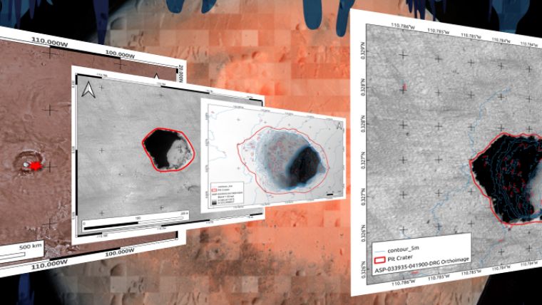
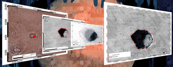
The scientists demonstrated the results that can be achieved with the help of the planet-mapping software with a specific landform on Mars resembling lava tubes on Earth. Geological maps are an important tool in planetary exploration because they also serve as a basis for possible exploration by robots or humans.
The research article in Earth and Space Science can be found here

Value staying current with geomatics?
Stay on the map with our expertly curated newsletters.
We provide educational insights, industry updates, and inspiring stories to help you learn, grow, and reach your full potential in your field. Don't miss out - subscribe today and ensure you're always informed, educated, and inspired.
Choose your newsletter(s)


