SBG Systems Releases Virtual Base Station Feature in Qinertia
SBG Systems is introducing the Virtual Base Station feature in its in-house post-processing software called Qinertia. Geospatial professionals benefit from an optimal centimetric position accuracy in all their projects, even for corridor mapping and in poorly covered RTK areas.
Qinertia is SBG Systems’ in-house GNSS and INS post-processing software. It gives access to offline RTK corrections from more than 7,000 base stations located in 164 countries. Trajectory and orientation are then greatly improved by processing inertial data and raw GNSS observables in forward and backward directions.
Corridor survey accuracy
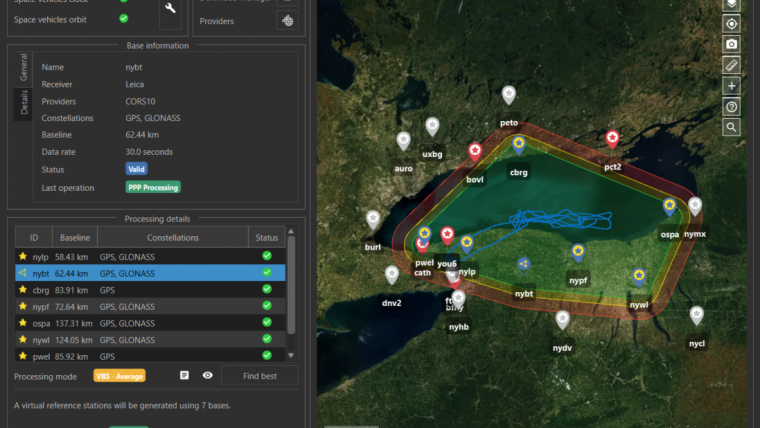
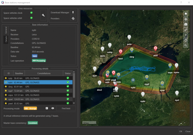
Qinertia PPK software now includes a brand new Virtual Base Stations (VBS) functionality. The VBS consists of computing a virtual network around your project in which position accuracy is maximized, homogeneous, and robust like a PPK short baseline is. Surveyors can collect data far from base stations or over large areas, making it ideal for corridor mapping. After the mission, Qinertia chooses the most relevant reference stations, builds a virtual network, and brings your project to centimetric accuracy with neither jump on accuracy nor convergence effects, even in urban areas.
Hardware agnostic
Qinertia has been designed to support all GNSS receivers and third-party IMUs. SBG Systems has worked very hard to offer a VBS which takes the most out of any GNSS receivers from different brands, models, with different configurations or constellations, and even with different coordinate systems. Qinertia automatically adjusts the VBS network to compensate for any base station position inaccuracy and provides full quality control indicators to assess the expected accuracy and reliability. Qinertia VBS technology can mix users' base stations with permanent network base stations to improve accuracy in remote locations. Even with this VBS computation, Qinertia remains the fastest post-processing software because it parallelizes the calculation of every base station in the virtual network and simultaneously processes the Forward and Backward computations. A typical UAV survey can be computed in less than a minute, and VBS computation doesn’t mean increasing your project time!
The software automatically selects the best positioning technology that applies to the project, whether it is a single base station mode, the Virtual Base Stations mode, or a Precise Point Positioning computation. Control is still in the user’s hands: the user can manually choose the mode, take a base station away, add a new one, while Qinertia automatically re-checks and re-computes all parameters simultaneously to validate the accuracy and consistency. The user is invited to check every step and can consult various quality control indicators such as separation, standard deviation, bias, scale factor, lever arm, as well as export statistics reports (RMS, min/max).

Value staying current with geomatics?
Stay on the map with our expertly curated newsletters.
We provide educational insights, industry updates, and inspiring stories to help you learn, grow, and reach your full potential in your field. Don't miss out - subscribe today and ensure you're always informed, educated, and inspired.
Choose your newsletter(s)


