Scottish Wind Farm Survey Reveals Mediaeval Archaeology
Specialist spatial data solutions-provider Fugro-BKS (UK) recently completed an airborne light detection and ranging (Lidar) survey of five onshore wind farm sites near Caithness in Scotland for RES and Baillie Windfarm Ltd. It has also completed a more conventional topographic survey of another site near Aberdeen, this time for the JNP Group working on behalf of RES.
Chris Boreland, Business Development Manager of Northern Ireland-based Fugro-BKS, said that a recent airborne Lidar assignment at Caithness presented lots of challenges. One site was adjacent to the Dounreay nuclear power station, necessitating special flight permissions to fly over the site. This survey, undertaken for an archaeological company (AOC Archaeology Ltd), was part of a major archaeological landscape survey in Caithness and is one of the most detailed landscape mapping exercises ever undertaken in Scotland. The results will be made available to the public through a dedicated website. In this instance the Lidar survey recorded in detail the Baillie Hill landscape prior to the wind farm construction.
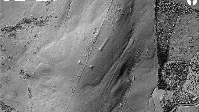
The survey was used to record the setting of one of the most important clusters of Neolithic funerary monuments in Caithness, at Cnoc Freiceadain (image), offering a unique view of the sites in their landscape context. Processing the data brought to light a large number of unrecorded features, greatly increasing the number of known hut circles in the area and redefining the extent of mediaeval and later settlement and agriculture. The data set therefore constitutes an invaluable research tool and an unparalleled means of preserving the landscape of 21st-century Caithness for future reference.
Chris Boreland sees an increase in the use of airborne Lidar surveys for wind farm developments, of which he thinks a benefit is the rapid collection of a high-accuracy 3D terrain model of the survey area. In the case of Fugro-BKS’s FLI-MAP system, a further benefit is the ability to measure ground height information underneath dense vegetation, defining the ground surface, rocks, mounds and tracks that are otherwise obscured and impossible to map by other means.
Project developers and consultants are increasing their use of geospatial information, such as the terrain data derived from Lidar, in a variety of ways. Prior to construction it can be used for wind speed analysis, vegetation cover, roughness, and clearance, view shed analysis, slope stability analysis, access road design, and for environmental and archaeological assessments. This information is an invaluable aid for turbine location selection and volumetric calculations for crane pad construction, as well as providing corridor mapping for network grid connection and substation location selection.
Image: 50cm grid Lidar elevation model of the chambered long cairns on Cnoc Freiceadain

Value staying current with geomatics?
Stay on the map with our expertly curated newsletters.
We provide educational insights, industry updates, and inspiring stories to help you learn, grow, and reach your full potential in your field. Don't miss out - subscribe today and ensure you're always informed, educated, and inspired.
Choose your newsletter(s)


