senseFly Launches New UAV Flight Planning and Management Software
senseFly, a Swiss provider of integrated, professional unmanned aerial vehicle (UAV or 'drone') solutions, has released a groundbreaking new version of its flight and data management software, eMotion. With a range of new features and functionalities, eMotion 3.5 has been designed to make the working lives, and workflows, of geospatial professionals simpler and more efficient.
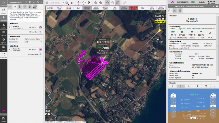
The software now supports uAvionix’s PingUSB ADS-B*/UAT receiver, allowing senseFly operators to view live air traffic data during their missions. This live data feed both helps improve airspace awareness and could potentially boost the number of mission types possible, such as projects taking place in congested airspaces like airports and longer-range BVLOS operations.
Multi-fight mapping missions
eMotion 3.5 also further improves the efficiency of multi-flight senseFly missions. Capable of resuming a multi-flight mapping mission – for example after a battery change – at the exact position the mission previously reached, the software ensures zero duplication of flight lines and image captures, for a seamless continuation of the user’s mission.
By using the new system, operators will be able to transform the georeferenced imagery of any senseFly RGB camera into an automatically-generated project (in .jxl format). This enables the simple, one-click import of drone imagery into Agisoft PhotoScan photogrammetry software without the need for manual project creation and organisation of images. Crucially, eMotion’s Agisoft projects also include geotag precision data; essential for RTK/PPK flights that generate results with high absolute accuracy.
eMotion is the most highly-regarded and powerful software of its kind in the professional drone space, said Alexis Roze, senseFly’s eMotion product owner. These exciting additions further distance eMotion from the pack, bringing many more commercial UAV operators across the world the exact functionality they need to collect accurate geospatial data as easily and efficiently as possible.
For more information on eMotion 3.5, go to www.sensefly.com.
* ADS-B data transmission is mandatory for airliners and standard-sized aircraft, plus many small aircraft also being equipped with this technology. For example, in the US, the FAA will require ADS-B to be installed in any aircraft wishing to fly in controlled airspaces (such as airports).

Value staying current with geomatics?
Stay on the map with our expertly curated newsletters.
We provide educational insights, industry updates, and inspiring stories to help you learn, grow, and reach your full potential in your field. Don't miss out - subscribe today and ensure you're always informed, educated, and inspired.
Choose your newsletter(s)


