Sentinel-3A Demonstrates Ability to Track Sea-level Change
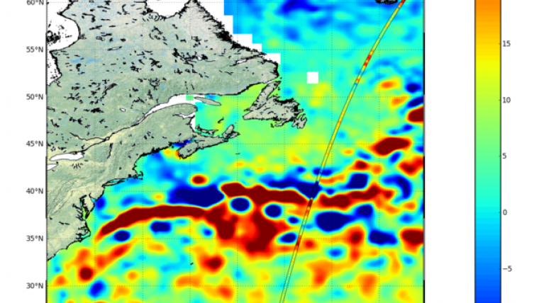
Following the first impressive images from Sentinel-3A, the latest Copernicus satellite has now demonstrated how its altimeter can track sea-level change. Just after the radar altimeter instrument was turned on, it traced the height of the sea surface over a stretch of the North Atlantic, some of the most dynamic ocean waters in the world.
Showing features relating to the Gulf Stream, the track compares very well with the background map of sea-surface height. The map, produced by the Copernicus Marine Environment Monitoring Service, comprises near-real-time data for one day from the CryoSat, Jason-2 and SARAL/AltiKa satellites.
Sea-level rise
The altimeter is designed to deliver accurate measurements of sea-surface height, significant wave height and surface-wind speeds over the world’s oceans for Copernicus ocean forecasting systems and for monitoring sea-level change. On average, the global sea-level has been rising at a rate of just over 3 mm per year over the last 20 years. However, this figure varies considerably around the world. The Sentinel-3 mission will offer valuable insight into these important variations.
Pierre-Yves Le Traon from Mercator Ocean said these first results are very promising and illustrate the great potential Sentinel-3 has for the Copernicus Marine Environment Monitoring Service. Sea-surface height data from the satellite’s altimeter will, for example, significantly improve the capability to analyse and forecast ocean currents. This is essential for applications such as marine safety, ship routing and predicting the fate of marine pollution events.
Wave height
Another set of data shows how the altimeter will be used to map ‘significant wave height’, which again is important information needed for ship safety. It will also provide accurate topography measurements over sea ice, ice sheets, rivers and lakes.
The altimeter has heritage from the CryoSat and Jason missions. This first image is in low-resolution mode but it will provide measurements at a resolution of approximately 300 m in the along-track direction after processing.
It will be the first satellite altimeter to provide 100% coverage over all of Earth’s surfaces in ‘synthetic aperture radar mode’, directly resulting from experience with CryoSat.
Sentinel-3A has shown that the first two instruments are working well. Now engineers and scientists are expecting the first data from its radiometer – which measures radiation from Earth’s surface – in the next couple of days.

Value staying current with geomatics?
Stay on the map with our expertly curated newsletters.
We provide educational insights, industry updates, and inspiring stories to help you learn, grow, and reach your full potential in your field. Don't miss out - subscribe today and ensure you're always informed, educated, and inspired.
Choose your newsletter(s)


