Software with Strip Adjustment Streamlines Point Cloud Acquisition for 3D Mapping
A newly enhanced software program from YellowScan, an international geomatics company based in France, is streamlining the acquisition of point-cloud data for Lidar. In March, the company announced the release of its new strip adjustment module, a point cloud-enhancing toolbox for its proprietary Lidar software, CloudStation.
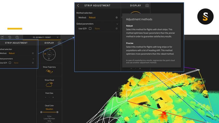
Even with high-end Lidar systems, some data refinement is required to improve precision and accuracy; the catch is that strip adjustment software is often complex. Here, the adjustment of strips or flight lines and the production of LAS files are done in a few clicks.
The Robust method is typically suitable for area-like (or parcel-like) coverage with short strip length. The method will optimize each strip segment parameters in order to produce the best blend. The Precise method on the other hand is suitable for corridor-like acquisitions with longer strips. This method aims to optimize strip parameters at a finer level (or time-window) than the robust method enhancing event further the coherence of the final point cloud.
Both methods include an iteration of boresight calculation and the possibility to use ground control points (GCPs) to better adjust to ground truth points.
Trajectory
The most sensitive and important data in a Lidar survey is the trajectory. Everything is based on the trajectory, which acts as the spine for your Lidar points. CloudStation software has been simplified so that it automatically generates flight line segments.
This refined version of CloudStation with strip adjustment provides a complete solution to create and visualize point-cloud data. It permits surveyors to extract, process and display data immediately after flight acquisition. The software enables to check the integrity of the data in the field, verify the area coverage, make sure all objects that are being mapped are identified, extract LAS files within a few minutes and automatically suggest flight lines.
With CloudStation mapping and surveying professionals can choose to color their data by intensity, echo number, scan angle or strip. From a user perspective, going through CloudStation with Strip Adjustment is among the best new best practices to deliver the highest point cloud precision and accuracy.

Value staying current with geomatics?
Stay on the map with our expertly curated newsletters.
We provide educational insights, industry updates, and inspiring stories to help you learn, grow, and reach your full potential in your field. Don't miss out - subscribe today and ensure you're always informed, educated, and inspired.
Choose your newsletter(s)


