Solution to Achieve Centimetre-level Accuracy
Supergeo, a Taiwan-based GIS software and solution provider, will be releasing NTRIP solution on its Windows Mobile GIS app, SuperPad, for high-accuracy field data collection and geospatial workflow enhancement. The upcoming SuperPad 3.3 version will support the NTRIP solution with RTK technology.
SuperPad is a feature-rich mobile GIS application for field-based personnel to collect, edit, display and measure spatial data. The flexible development environment and customised extensions enable users to create a platform that fits their needs.
RTK technology
A major upgrade of SuperPad 3.3 is the support of the NTRIP solution with RTK technology. Real Time Kinematic (RTK) satellite navigation, one of the latest and widely used technologies within the field of Differential GNSS (DGNSS), significantly enhances the precision of the positioning data. RTK positioning can greatly raise the accuracy to centimetres level.
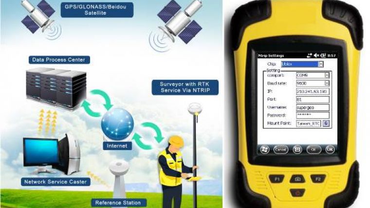
With the NTRIP solution, SuperPad can not only be capable of handling post-process DGNSS workflow, but also allow users to connect to respective network RTK service provider with NTRIP protocol, aimed to bring a convenient and highly accurate real-time data collecting workflow for advanced field work.
GNSS
The NTRIP solution of SuperPad allows user to connect with NTRIP caster service like virtual reference station (VRS) RTK service provider or private station services. According to the company, its simple operations for turning on the module and quick-to-use settings will save much time for surveyors and widely support mainstream GNSS modules like U-Blox, Hemisphere and NovAtel.
Progress of the SuperPad NTRIP Extension is also visualised as a condition monitoring informer on the map intuitively. Users looking for high accuracy or precision status with the RTK correction will find more details about the fixing mode and GNSS information presented clearly with the renewed GPS Status pages.

Value staying current with geomatics?
Stay on the map with our expertly curated newsletters.
We provide educational insights, industry updates, and inspiring stories to help you learn, grow, and reach your full potential in your field. Don't miss out - subscribe today and ensure you're always informed, educated, and inspired.
Choose your newsletter(s)


