Teledyne launches real-time airborne Lidar workflow solution
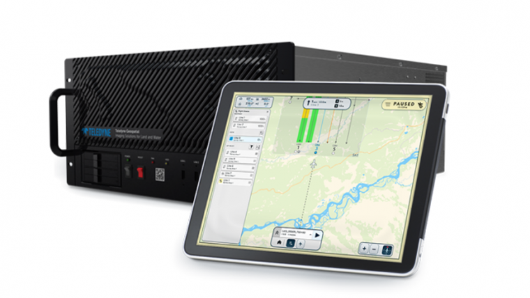
Teledyne Geospatial has released the Galaxy Onboard, a workflow-focused solution that enables airborne surveyors to deliver quality-controlled processed data in real time. With Galaxy Onboard, Teledyne Geospatial has lowered the barrier of entry for organizations venturing into airborne mapping with a solution that does not require in-depth expertise or months of training.
Galaxy Onboard will also offer extra value to airborne surveyors allowing them to explore additional applications. Through real-time quality control during acquisition, Galaxy Onboard enables a faster-than-ever turnaround time for governmental wide-area programmes and engineering-grade corridor applications. In addition, life-threatening incidents such as hurricanes, storms, power outages and floods will now have the benefit of Galaxy Onboard’s ability to process 3D data in real time, making it available for recovery, rescue and restoration deployment while the aircraft is still in the air.
Revealing obscure information in real time
Comprised of a rugged onboard computer, with a sophisticated real-time processing engine and quality control system, Galaxy Onboard extends the Lidar sensor into a full solution that accelerates the workflow from aircraft to office and instils organizational confidence in data integrity.
"Galaxy Onboard was engineered to delight our customers by accelerating on-time final deliverables, reducing processing time, and automating manual and error-prone work. Onboard will generate confidence by revealing obscure information in real time. Onboard’s intuitive design effectively showcases our user obsession and provides immediate efficiencies without compromising on productivity,” said Malek Singer, Teledyne Geospatial’s airborne product manager.
Teledyne Geospatial unifies the hardware and software expertise of both Teledyne CARIS and Teledyne Optech. The new group provides customers with innovative integrated solutions. Offerings include turnkey systems, Lidar and sonar integrated workflows and a range of systems and solutions that support holistic, precision data collection.

Value staying current with geomatics?
Stay on the map with our expertly curated newsletters.
We provide educational insights, industry updates, and inspiring stories to help you learn, grow, and reach your full potential in your field. Don't miss out - subscribe today and ensure you're always informed, educated, and inspired.
Choose your newsletter(s)


