UAV-Lidar to Improve Powerline Vegetation Management
A recent forestry-based case study demonstrates the value of remote sensing techniques such as UAV-Lidar for identifying diseased or damaged trees and overgrown vegetation close to powerlines to prevent outages or forest fires.
The project was conducted at Pound Farm in Suffolk, UK, aimed at identifying trees in poor health, along with overgrown vegetation that posed a risk of damage to the powerlines running through the forest. The companies Routescene, 2Excel Geo, Fera Science and Dielmo 3D collaborated to provide the results to the land owner, Woodland Trust.
The survey site
The site of 49 hectares (120 acres) consists of ash, oak, maple and birch, amongst other tree species, and is a mix of young and ancient woodland complete with wildflower meadows. There are 33kV powerlines cutting through the middle of the wood.
The area has been affected in recent years by ash dieback which is highly destructive. Caused by the fungus Hymenoscyphus fraxineus, which originated in southeast Asia, it can kill young and coppiced ash trees quickly. Older trees may be able to resist the disease for some time. Symptoms include a blackening and wilting of leaves in mid to late summer.
Four different imaging techniques - Lidar, RGB, multispectral and hyperspectral - were used to appraise the ability of each to identify signs of ash dieback.
Benefits of UAV-Lidar
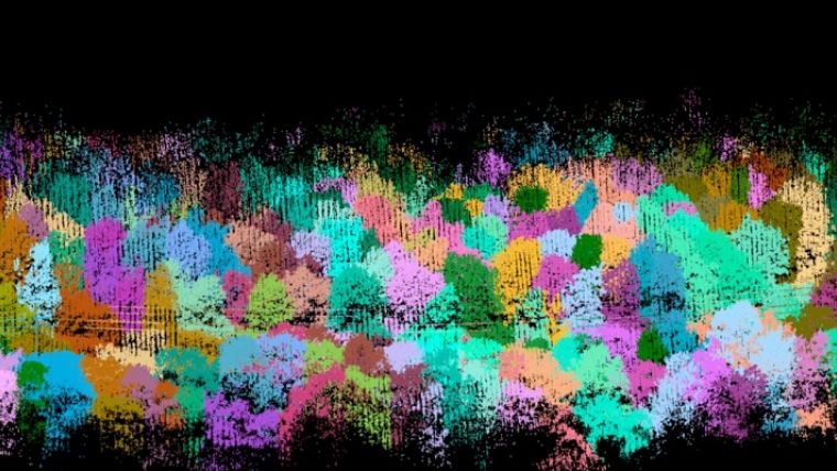
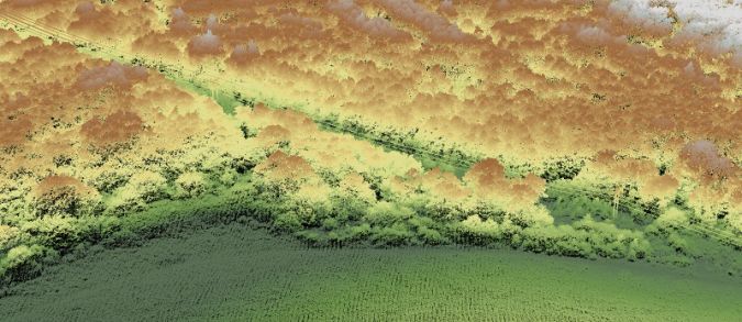
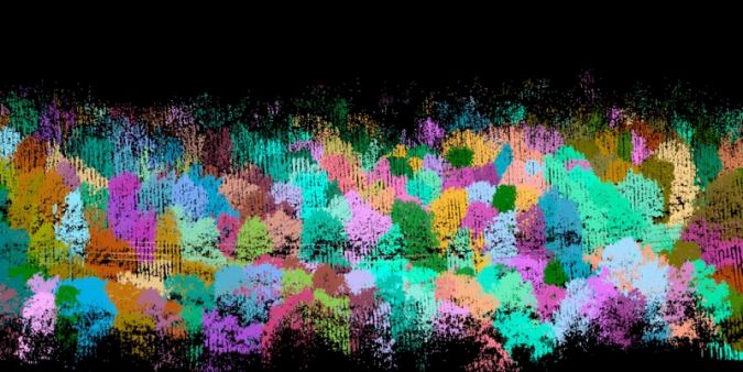
The excellent vegetation penetration capabilities of the Routescene Lidar system enabled a profile of an individual trees to be compiled from ground level to the canopy to examine tree health. Density analysis of the Lidar data gathered from the crown of the trees was be used to identify disease. In addition, Lidar can capture the thin powerlines easily to establish the proximity of vegetation surrounding it. Lidar is not affected by shadows, which is a problem for RGB imagery, and can be collected at any time of day.
In-depth processing of the Lidar data was undertaken using Routescene's LidarViewer post-processing software. The team created a digital terrain model (DTM) to precisely locate the powerlines and pylons. The DTM was used in conjunction with a digital surface model (DSM) to ascertain the height of the trees (the canopy height being the difference between the DSM and DTM). This was used to calculate the normalized height and help identify individual trees.
RGB, hyperspectral and multispectral
Using RGB imagery it becomes very easy to visualize the trees, for example to view the colour of the leaves to determine tree health. RGB imagery can be merged with Lidar data, giving each Lidar point an RGB value, to colourise the point cloud. This provides true, life-like colour to the Lidar images, making them easier to interpret.
Hyperspectral and multispectral imaging data was collected by both light aircraft and drone. These instruments capture data which is beyond the range of human vision. When statistically analysed, this data can help to identify the species, health and stress of the trees. In this project 18 vegetation indexes were used to check tree health. The best known is the Normalised Difference Vegetation Index (NDVI), which is a function of red and near-infrared energy that can indicate leaf area index, plant biomass and growth vigour.
Identifying trees causing risk to the powerlines
The Lidar point cloud was combined with the multispectral and hyperspectral imagery using a series of machine learning approaches. The various vegetation indices, colour and point cloud densities were analysed to look for evidence of disease. For example individual trees without leaves, with different colours of leaves, different vegetation index results or lower point cloud density values in the top layer of the tree canopy can all suggest disease. Density analysis of the Lidar data and hyperspectral data was then carried out, using data from the top two metres of the tree crown, to identify disease.
Finally the team needed to provide outputs which could easily be interpreted by the Woodland Trust who are not geospatial specialists. Lidar data was exported to Dielmo 3D's web based portal for visualization and reporting. These results were used to identify areas along the powerline at risk from overgrown vegetation and diseased trees in danger of falling and striking the powerlines. The analysis specifically focused on trees in close proximity to the powerline to produce an overgrown vegetation and ash dieback risk map.
Useful outputs from UAV-Lidar data
This survey confirms the suitability of using UAV-Lidar data to assess tree health. The results enabled the team to highlight areas of vegetation encroachment posing potential danger to the powerlines and 'at risk' trees suffering from ash dieback which may cause damage to the powerlines. This information can be used to develop vegetation management plans to reduce the risk of power outages and forest fires caused by branches and vegetation hitting the powerlines.
Dr Chloe Barnes, from 2Excel Geo, commented: “The high-density point cloud from the Routescene UAV-Lidar system facilitated the improved detection of individual trees within the woodland. The structural information provided by the Lidar also provided complimentary datasets to the spectral information from the airborne imagery for tree health and species classification.”
Gert Riemersma, CTO and founder of Routescene, said: “This project showcased how useful and practical the outputs created from UAV-Lidar data can be to recognize areas of disease within a woodland. It also demonstrated perfectly how high-resolution UAV-Lidar surveys can be used to identify individual powerlines and determine which trees and vegetation may cause damage either as a result of growth or disease.”

Value staying current with geomatics?
Stay on the map with our expertly curated newsletters.
We provide educational insights, industry updates, and inspiring stories to help you learn, grow, and reach your full potential in your field. Don't miss out - subscribe today and ensure you're always informed, educated, and inspired.
Choose your newsletter(s)


