USGS Continues to Expand Crowdsourcing Project
The U.S. Geological Survey (USGS) continues to expand its crowdsourcing activities for geographic data and is seeking volunteers nationwide to contribute structures information. The mapping crowdsourcing programme, known as 'The National Map Corps' (TNMCorps), encourages citizens to collect structures data by adding new features, removing obsolete points and correcting existing data for The National Map database. Structures being mapped in the project include schools, hospitals, post offices, police stations and other important public buildings.
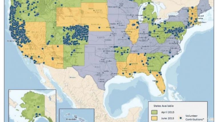
Since the start of the project in 2012, more than 780 volunteers have made in excess of 13,000 contributions. In addition to basic editing, a second volunteer peer-review process greatly enhances the quality of data provided back to The National Map. A few months ago, volunteers in 35 states were actively involved. This final release of states opens up the entire country for volunteer structures enhancement.
To show appreciation of the volunteers' efforts, The National Map Corps has instituted a recognition programme that awards 'virtual' badges to volunteers. The badges consist of a series of antique surveying instruments ranging from the Order of the Surveyor's Chain (25 – 50 points) to the Theodolite Assemblage (2000+ points). Additionally, volunteers are publically acclaimed (with permission) via Twitter, Facebook and Google+.
TNMCorps volunteer Don Kloker commented that he enjoys mapping structures, a unique combination of validating structures from aerial photography and web-based sources. His structures contributions have provided him with an excellent geography lesson and Kloker has learned many things about communities that he most likely would not have been otherwise able to experience. Don has contributed more than 2,000 points and quickly reached the highest recognition badge, the Theodolite Assemblage.
The citizen geographers/cartographers who participate in the programme make a significant addition to the USGS's ability to provide accurate information to the public. Data collected by volunteers become part of The National Map structures dataset which is available to users free of charge.
Corey Plank, cartographer for the US Bureau of Land Management, said that TNMCorps allows him to update structure locations and their official names from the Geographic Names Information System (GNIS). These updates allow The National Map and US Topo map series to better represent ground structures and official labels.
As part of an effort to engage civilian organisations, this year's 4-H National Youth Science Day, planned for 9 October 2013, will feature geographic technology projects that are part of TNMCorps data collection efforts.
Tools on TNMCorps website explain how a volunteer can edit any area, regardless of their familiarity with the selected structures, and becoming a volunteer for TNMCorps is easy: simply go to The National Map Corps website to learn more and to sign up as a volunteer. All participants need is access to the internet and a willingness to dedicate some time to editing map data.

Value staying current with geomatics?
Stay on the map with our expertly curated newsletters.
We provide educational insights, industry updates, and inspiring stories to help you learn, grow, and reach your full potential in your field. Don't miss out - subscribe today and ensure you're always informed, educated, and inspired.
Choose your newsletter(s)


