Using Earth Observation Satellite Data to Monitor Global Water Quality
EOMAP has built the world’s first global water quality portal using Earth observation and satellite data to support the International Initiative on Water Quality (IIWQ) of UNESCO’s International Hydrological Programme (IHP). The comprehensive IIWQ World Water Quality Portal will assist with global water quality assessment and capacity building for streams, lakes and rivers. The launch is taking place at UNESCO headquarters, and an exhibition on 'Satellite-based Water Quality Monitoring' is available from 22-26 January 2018.
The degradation of water quality threatens human health, limits food production, reduces ecosystem functions and hinders economic growth. Newly emerging pollutants and changing climate patterns bring about a new water quality challenge with still unknown long-term impacts on human health and ecosystems. Monitoring water quality is essential to determine the health of freshwater systems as well as identify signs of degradation over weeks, months and years.
Sustainable Development Goals
International agencies recognise the growing need to monitor the effects of pollution on our water cycle. Dr Sarantuyaa Zandaryaa, programme specialist, Division of Water Sciences UNESCO-IHP, said in view of scarce water quality information at the global and national levels, the Portal will be a valuable tool to obtain water quality information, especially in remote areas and in developing country regions such as Africa, Asia, Latin America, and SIDS where water quality monitoring networks and laboratory capacity lack. It is also a decision-support tool and will help countries identify the most pressing water quality problems such as pollution hotpots. Hence, the Portal will support national efforts for the implementation of water quality related SDG targets as well as for monitoring progress towards their realisation.
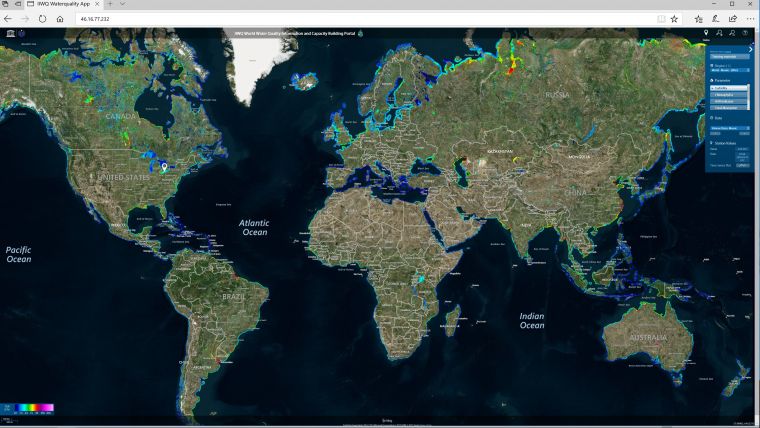
UNESCO-IHP IIWQ World Water Quality Portal
Based on EOMAP’s web service, the IIWQ Portal is a cost-saving solution to water quality monitoring providing users with near real-time data, campaign planning support, and access to remote and inaccessible areas. As a web-based service, users can quickly obtain measurements at freely selectable virtual stations for any location worldwide.
A comprehensive range of satellite-based water quality parameters such as turbidity, chlorophyll and indicators for toxic Cyanobacteria blooms can be mapped globally with weekly or even daily sampling frequencies under cloud-free conditions.
The IIWQ Portal also includes functionalities to select different time periods dating back over the last three decades. Historic measurements are provided at a 30m resolution for selected regions of each continent throughout 2016, and can be continued with various spatial and temporal resolutions for every country.
Remote sensing
Dr Thomas Heege, chief executive officer, EOMAP, pointed out that remote sensing is an efficient and cost-effective tool to assess a variety of physical and biological parameters in aquatic ecosystems over small-scaled and large areas. The IIWQ Portal can respond to the challenges that utilities and other agencies have for effectively monitoring and responding to water quality threats such as algal blooms and turbidity. It is the first portal to combine high resolution global coverage with the range of measurements needed for effective global water quality monitoring and user-friendly features.
Heege added his team is thrilled to be chosen by UNESCO to support such an important programme and help promote collaboration to address global water quality issues. Water security is crucial in achieving sustainable development and thriving economies. EOMAP products and expertise are well positioned to support those goals, he concluded.
The water quality information is made freely and easily accessible through the IIWQ World Water Quality Portal. Environmental managers, politicians and scientists can ingest the service directly through the UNESCO web mapping service into their geospatial information systems for analysis and assessment.
EOMAP will launch an updated web application that incorporates additional interfaces and features such as guidance into risk management and application of Earth-Observation data.

Value staying current with geomatics?
Stay on the map with our expertly curated newsletters.
We provide educational insights, industry updates, and inspiring stories to help you learn, grow, and reach your full potential in your field. Don't miss out - subscribe today and ensure you're always informed, educated, and inspired.
Choose your newsletter(s)


