virtualcitySYSTEMS Wins OGC CityGML Challenge
The virtualcitySYSTEMS team was named the winner of the OGC CityGML Challenge at the OGC Toulouse Meeting in November 2019. CTO Claus Nagel joined the award ceremony in Toulouse and presented the prize-winning solution. The company expressed its thanks to OGC for developing the geospatial standards it uses as the foundation for its applications.
(This news story contains a video)
In late October 2019, the Open Geospatial Consortium (OGC) CityGML 3.0 Challenge, sponsored by Ordnance Survey, the Manchester City Council and the Triangulum EU project, was held in Manchester for the first time. The aim of the OGC CityGML Challenge was to develop software solutions that support the upcoming version 3.0 of CityGML as well as the integration of dynamic sensor data.
Thematic and planning data
CityGML models are used successfully around the world, and most major cities and national surveys in Germany rely on this OGC standard for processing, managing and sharing 3D geodata. North Rhine-Westphalia, Thuringia, Berlin and Hamburg as well as further cities provide CityGML models as open data.
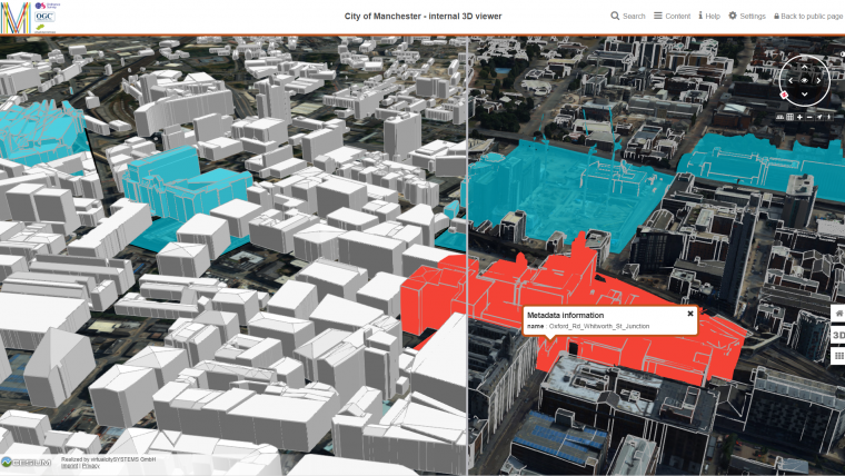
virtualcitySYSTEMS, HFT Stuttgart and CSI Piemonte were the finalists in the OGC CityGML Challenge in Manchester and developed solutions with a strong commitment. Manchester provided a range of datasets including building, terrain and sensor data in formats such as CityGML, Shapefile or GeoJSON.
All participants showed with their work the great added value that CityGML models and open standards have over the pure visualization of urban and regional models. The presentation of semantic information that is possible with CityGML and the open integration of thematic and planning data will be indispensable in the future.
virtualcitySYSTEMS convinced the jury with its intuitive 3D web viewer and its innovative solutions for creating and presenting planning scenarios in the city model, exporting CityGML 3.0 to many common 3D formats, editing attributes in real-time as well as with the solar potential analysis that was conducted and integrated into the model. In the coming year, the application will be made publicly available for innovation purposes.

Value staying current with geomatics?
Stay on the map with our expertly curated newsletters.
We provide educational insights, industry updates, and inspiring stories to help you learn, grow, and reach your full potential in your field. Don't miss out - subscribe today and ensure you're always informed, educated, and inspired.
Choose your newsletter(s)


