Volunteer OSM Contributors Add Data After Typhoon Haiyan
'Crisis mapping' by volunteers is on the rise and is making an increasingly important contribution to professional disaster management. This was confirmed during a conference on social media in disaster management in Heidelberg, Germany, last month. A good example is the number of volunteer contributors to OpenStreetMap who added data to the Philippines after Typhoon Haiyan: the number of OSM crisis mappers had passed the 1,000 mark after only one week.
Compared with the biggest OSM crisis mapping event so far, the earthquake in Haiti 2010: a month after the earthquake, the number had not passed 700. This shows that the relevance of OSM crisis mapping is increasing all the time. More importantly, also the co-ordination with professional organisations in disaster management and humanitarian aid from the Red Cross to the UN is much better nowadays. This assures that the data generated is actually being used for the intended purpose. Still, the crisis mappers rely on the availability of high-resolution satellite imagery - in particular post-disaster imagery. The availability of such sources and the speed of making such imagery available to the OSM crisis mapping community still needs to be enhanced.
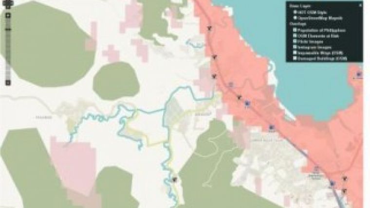
Map Layers
For supporting the disaster management activities after the typhoon Haiyan a new Crisis Map has been set up by GIScience Research Group at Heidelberg University that visualises map layers as the map layers showing population density and "elements at risk" for the Philippines. Credits for this voluntary effort go to Pascal Neis, Andreas Reimer, Maxim Rylow, Bernd Resch, Günter Sagl, João Porto and colleagues.
Also new map layers displaying damaged buildings and impassable roads (both OSM) as well as geolocated images from Instagram have been added and are updated regularly.
Sometimes the difficulty is just not having a convenient way to display or access extant data sources. As a service to the crisis mappers, a Tile Service showing the residential population distribution in the Philippines in 90m resolution has been made available. The data are from the AsiaPop project, for details see the notes in the URL given below.
Data Model
The "Elements at Risk" layer contains information about critical elements at risk (e.g. schools, hospitals etc.) and is fundamental to support response activities. It is derived from a data model developed by the AGORA group of GIScience Heidelberg and the University of São Paulo, Brazil, for leveraging OpenStreetMaps (OSM) to automatically identify hazard-specific elements at risk. The data model is based on well-established risk assessment methodologies such as the HAZUS methodology from FEEMA and aggregates the most important OSM tags for enabling quick identification of the most critical entities that are mapped in OSM. More details on the approach can be found here. This data model has been implemented as new map layer of OpenMapSurfer by Maxim Rylow and colleagues.
Also a Mapathon to support crisis mapping with OpenStreetMap has been organised by Andreas Reimer and colleagues at Heidelberg University on 14 November 2013. This included a live video introduction to the relevant tasks to be performed by the OSM H.O.T main coordinator for the Haiyan disaster Andrew Buck. More than 200 geography students at the Department of Geography of Heidelberg University will now be editing OSM maps according to H.O.T task assignments at least over the next week, thus improving the quality of the free and open geographic data for the Philippines.

Value staying current with geomatics?
Stay on the map with our expertly curated newsletters.
We provide educational insights, industry updates, and inspiring stories to help you learn, grow, and reach your full potential in your field. Don't miss out - subscribe today and ensure you're always informed, educated, and inspired.
Choose your newsletter(s)


