Woolpert to Collect Aerial Lidar Data for 3D Elevation Programme in Ohio
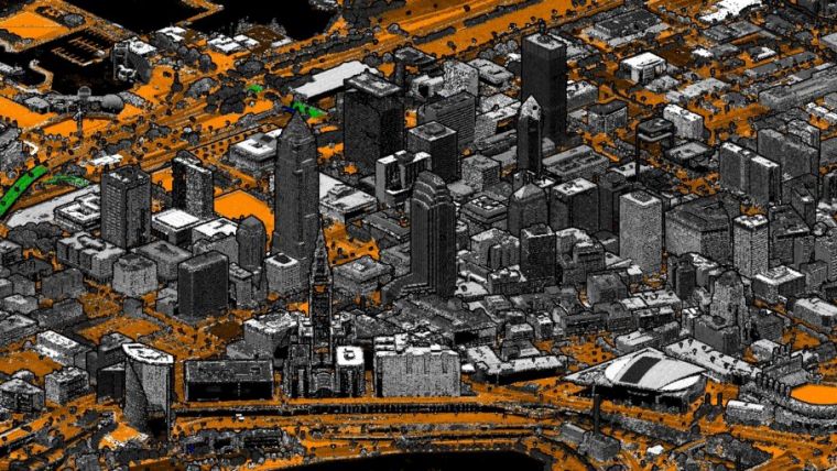
Woolpert has been contracted to collect topographic Lidar data and provide ground control survey to support the third phase of the Ohio 3D Elevation Program (3DEP) in the USA. This phase will cover roughly 13,000 square miles in the southwest portion of the state, including Columbus, Cincinnati and Dayton.
This contract to collect Quality Level 1 Lidar data was awarded by the U.S. Geological Survey through its Geospatial Product and Service Contract 3 and directly supports 3DEP. The Ohio 3DEP contract is being administered by the Ohio Geographically Referenced Information Program, an office within the Ohio Department of Administrative Services, with funding support from the Ohio Department of Natural Resources, the Ohio Environmental Protection Agency, the Ohio Department of Administrative Services and the Ohio Department of Transportation. The Lidar data will be made publicly available and can be used by agencies, governments and individuals throughout the state.
The benefits of high-resolution Lidar
Woolpert geospatial project manager Jennifer Sturges said the firm is collecting QL1 Lidar data for this contract because local governments and state agencies have found greater value in high-resolution Lidar data. She said higher-quality data generates expansive benefits and provides ongoing returns on investment.
“By upgrading the quality of the data collected, more features can be extracted, which supports more detailed analysis and modeling and more accurate products,” Sturges said. “Higher-quality data also can contribute to the future use of that information through artificial intelligence and machine learning.”
Woolpert has also collected Lidar data and imagery as part of all three phases of the Ohio Statewide Imagery Program and has been actively engaged with state agencies to develop use cases and applications for this data. Woolpert vice president Brian Stevens said that, due to the point density of the data and the oversight of the USGS, the data collected will be published to The National Map. The National Map is a collaborative effort between the USGS and other federal, state and local partners to improve and deliver topographic information across the country for uses ranging from recreation to scientific analysis to emergency response.
“USGS does a full quality assurance/quality control review of the data collected, benefiting both them and the state, making it a win-win,” Stevens said. “This contract also is a win for Woolpert, both personally and professionally. We were founded in Dayton 110 years ago and conducted the first statewide Lidar data collection in Ohio in 2006. Ohio has been progressive in its use of data and GIS, helping advance multiple technologies and encouraging agencies to collaborate and work better together. This is our home, and we’re honoured to support it.”
The Lidar data for this contract will be acquired this winter and will be delivered in summer 2022.

Value staying current with geomatics?
Stay on the map with our expertly curated newsletters.
We provide educational insights, industry updates, and inspiring stories to help you learn, grow, and reach your full potential in your field. Don't miss out - subscribe today and ensure you're always informed, educated, and inspired.
Choose your newsletter(s)


