Iranian Permanent GPS Network
Lying in one of the most tectonically active zones in the Alpine-Himalayan belt, Iran frequently suffers from heavy and disastrous earthquakes. To monitor surface displacement and measure velocity and...
Geodesy is the mathematical science of describing the shape of the earth. Though land surveying and topography could be considered part of geodesy, the latter is often understood as ‘higher’ geodesy, that is describing the larger shape of the earth. Geodesy provides the framework for all global positioning systems such as GNSS.
Geodesy is not only concerned with horizontal coordinate reference systems on the surface of the earth but also about defining vertical reference levels or chart datums such as those derived from water levels.
Lying in one of the most tectonically active zones in the Alpine-Himalayan belt, Iran frequently suffers from heavy and disastrous earthquakes. To monitor surface displacement and measure velocity and...
The urbanization trend is leading to an increasing number of people living in cities, thus also placing new demands on cadastral registration. To be able to register the complex infrastructures and bu...
15th July, Durban, South Africa The World Heritage Committee chaired by Themba Wakashe, South Africa’s deputy director-general for Heritage and National Archives has inscribed seventeen cultural si...

Geodesists and surveyors in Iceland face considerable challenges due to the deformation effects of earthquakes, volcanic eruptions and glaciers on the geodetic networks. This article provides insight ...
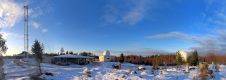
The Finnish Geodetic Institute (FGI) was established on 5 July 1918, just seven months after Finland gained its independence. The main task of FGI was the basic mapping of Finland, later to include pr...

Gerard de Kremer was born on 5 March 1512 in the small town of Rupelmonde, situated in the heart of what is now the Flemish region of Belgium. In his mid-teens, whilst studying in ‘s-Hertogenbosch, ...
The astronomer, mathematician and geodesist Carl Friedrich Gauss died 150 years ago. He is famous for his contributions to mathematics, but more directly of interest in a GIS context is his work to de...
What are the key challenges in establishing precise geodetic control networks? This is one of the most important tasks of geodesists and land surveyors, since geodetic control networks are essential f...

Chris Rizos, new president of the International Association of Geodesy (IAG), is advocating ‘modern geodesy' and a stronger, more visible role for the IAG. GIM International met Rizos in an early Ju...

A keynote address at the XXV FIG Congress (Kuala Lumpur, Malaysia, 16-21 June) by Chris Rizos, IAG president, on ‘Opportunities & Challenges for the Surveying Industry in a Multi-system GNSS World�...
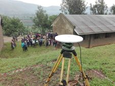
In line with the United Nations resolution to adopt a global geodetic reference network, the Government of Uganda received financing from the World Bank towards the cost of a competitiveness and enter...

The African Geodetic Reference Frame (AFREF) was conceived to unify the patchwork of geodetic reference frames and vertical datums in the 54 countries in Africa. A common reference frame is intended t...
A 3D-Earth viewer enables navigating through the virtual environment and can be easily downloaded from the internet. How might this rapid development support steady, long-term development of instituti...
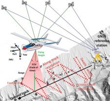
Today, automatic matching of overlapping aerial imagery and airborne Lidar are the main geodata technologies for capturing dense point clouds of the Earth’s surface. The sampled points are used for ...
During the last decade, GNSS (Global Navigation Satellite System) technologies experienced an accelerated growth, both in terms of quantity in use and quality. The accuracy achieved by technology prov...
This site uses cookies. By continuing to use this website, you agree to our Cookies Policy. Agree