The case for natural capital accounting
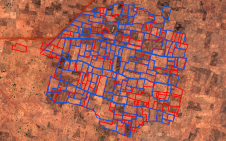
Case studies in the Philippines demonstrate the importance of timely geospatial information in natural capital accounting, which harmonizes environmental sustainability with economic exigencies. When ...
In land surveying the exact position and shape of objects on the surface of the earth is mapped. Included in the position is the height of an object. Techniques used are for example the total station, level instrument and GNSS. There is a direct relation between modern Remote Sensing techniques and land surveying and topography and often they are used side by side with land survey techniques providing highly accurate coordinates and remote sensing providing a broader overview. In traditional land surveying and topography objects are located in x,y and z with the addition of an object type. However, nowadays more and more attribute information is collected as well allowing detailed databases and products to be developed in cartography.
An important application for land surveying and topography is in construction and engineering but also in for example land and water management. Where land surveying and topography is about the visible objects on the earth surface, marine surveying and bathymetry is concerned with the objects under the water surface.

Case studies in the Philippines demonstrate the importance of timely geospatial information in natural capital accounting, which harmonizes environmental sustainability with economic exigencies. When ...
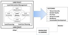
A special issue of the 'Land' journal highlights the latest Fit-For-Purpose Land Administration innovations, demonstrating that FFPLA is increasingly gaining momentum and acceptance. The Fit-For-Purpo...

Over the past 20 years, various initiatives have been launched reflecting the importance of cadastral data for land management and spatial development. But how have these initiatives enhanced the poss...
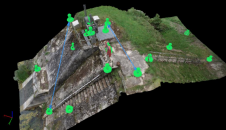
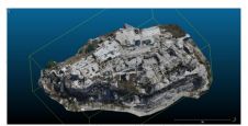
From drones and satellites to airborne-based sensors and Lidar, advances in remote sensing and geospatial information science are driving the development of innovative methods for data acquisition, pr...

Incorporating smart methodologies in cadastral surveying is improving the land acquisition system in Ghana. Traditional cadastral surveying is time-consuming and, if not planned out well, could cost a...
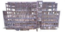
Terrestrial laser scanning is becoming increasingly important as the software and technology-related developments in many spheres of society mean that ever-higher standards are being set in terms of q...

The brand-new United Nations Global Geodetic Centre of Excellence (UN-GGCE) is now operational at the United Nations campus in Bonn, Germany. Nicholas Brown, head of office of the UN-GGCE, is dedicate...
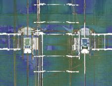
Read about this automated mobile laser scanning system developed for mining. It facilitates fast and precise measurements to produce a 3D model of the mine shaft for further analysis. Mine shafts are ...
As the FIG commission chairs near the halfway point in their terms, they reflect on the global and technological drivers influencing their work. This article describes the breadth of work across the F...
The focus of FIG Commission 2 is on innovative and effective professional education and training for surveyors. This involves curriculum development, innovations in teaching and learning, life-long le...
Some of the challenges demanding innovative surveying approaches and technologies are rapid urban growth, smart energy, cleaner mobility, and ‘land rights for all’. Sensing technologies, spatial d...

Clarissa Augustinus will give a presentation to the RICS on receipt of the Michael Barrett award on the 29 November 2018. Here she outlines the main points of her lecture. We live in an era of change ...
Current sources of Global Land Indicators are limited with only 30% of the globe covered. Robin McLaren believes that new, innovative sources of land information can strengthen our understanding of th...
In November 2004 an Expert Group Meeting on Secure Land Tenure was held at UN Headquarters in Nairobi, Kenya. The focus of this meeting was to discuss new legal frameworks for the improvement of land ...

A love of mathematics set one of Africa's foremost geo-information specialists on a mission to drive the development of spatial-data infrastructure across the continent Partnership and communication l...
This site uses cookies. By continuing to use this website, you agree to our Cookies Policy. Agree