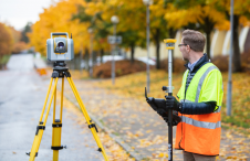
In land surveying the exact position and shape of objects on the surface of the earth is mapped. Included in the position is the height of an object. Techniques used are for example the total station, level instrument and GNSS. There is a direct relation between modern Remote Sensing techniques and land surveying and topography and often they are used side by side with land survey techniques providing highly accurate coordinates and remote sensing providing a broader overview. In traditional land surveying and topography objects are located in x,y and z with the addition of an object type. However, nowadays more and more attribute information is collected as well allowing detailed databases and products to be developed in cartography.

An important application for land surveying and topography is in construction and engineering but also in for example land and water management. Where land surveying and topography is about the visible objects on the earth surface, marine surveying and bathymetry is concerned with the objects under the water surface.

The changing role of the surveyor

The changing role of the surveyor

Although the essence of surveying has barely changed since the profession began, the increasingly complex digital continuum requires geospatial professionals to adapt their skills in dynamic and impor...

Reflections on HxGN LIVE Global 2023

Reflections on HxGN LIVE Global 2023

It is time to innovate with technology that can be applied ‘right here, right now’. That was the clear message during HxGN LIVE Global 2023. President and CEO Paolo Guglielmini set the tone with h...

Geospatial digital twins will make cities smarter

Geospatial digital twins will make cities smarter

Thanks to the ability of digital twins to provide insights into the reality of present conditions and the impacts of future scenarios, they have the potential to revolutionize the planning and efficie...

The invigorating geospatial vibes in Vegas

The invigorating geospatial vibes in Vegas

In the rapidly evolving landscape of geospatial technology, the annual Trimble Dimensions gathering is a dependable beacon for the surveying and mapping fields, providing a panoramic view of the curre...

Interoperability Requires Sustainable Choices

Interoperability Requires Sustainable Choices

After many years of indecision about the right way forward with respect to LandInfra/LADM alignment, it is time to re-open the debate on the development of standardization in the domains of land surve...

LADM-based Software

LADM-based Software

Just 18 months on from the publication of the ISO 19152 Land Administration Domain Model (LADM) at the end of 2012, it is becoming increasingly widely used. FIG initiated the development of this ISO s...

Mapping Indoor Spaces with an Advanced Trolley

Mapping Indoor Spaces with an Advanced Trolley

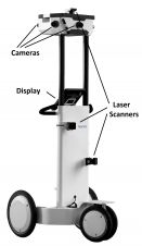
Few museums, shopping centres, airports and other indoor spaces have been mapped, although the demand for detailed 3D models of such spaces is accelerating rapidly. Here, the authors present a trolley...

Recent Advances in Geodata Acquisition Technologies

Recent Advances in Geodata Acquisition Technologies

Today’s geodata acquisition technologies combine microprocessors, computer power, solid state drives, complementary metal-oxide-semiconductor (CMOS) sensors, miniaturisation and many more developmen...

Digital Aerial Cameras - Product Survey

This issue of GIM International provides an extensive product survey on digital aerial cameras. In support of the specifications provided by this product survey, this article presents additional infor...

The surveyors of our world

The surveyors of our world

Did you know that surveyors have been indispensable to the development of the world since civilization began? John F. Brock takes us on a brief journey through the history of surveying. In today’s d...