
The GIM International magazine is the monthly magazine for the geomatics professional. Read the latest geospatial related articles at GIM International! Don't want to read online? We also have a print edition.
Main topics in the August edition of GIM International are:
Fit-for-purpose Land Administration
Global Land Tenure Security
Mobile GIS and Land Administration
Interview with Mark Reichardt, President/CEO of OGC
Geospatial Information Management and Land Governance
Insider's View by Kees de Zeeuw, Kadaster International
... and more
Feature: Sustainable Development
 Page 16-19: Sound land governance is fundamental to achieving the 2030 Global Agenda as set by the Sustainable Development Goals (SDGs) adopted by all the world’s leaders at the UN Summit in September 2015. This Global Agenda calls for a “data revolution” for sustainable development to empower people with information on the progress towards meeting the targets.
Feature: Global Land Tenure Security
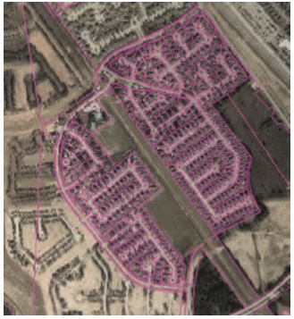 Page 20-21: Traditional techniques for developing land administration include highaccuracy field-based surveying of the property boundaries by certified surveyors, and may be still a desired solution for cadastral mapping in residential urban areas. The recent decade has seen a rise in high-detail and high-accuracy satellite imagery that is now able to capture large regions and update them on a periodic basis.
Perspective: Brent Jones, Esri Global Manager
 Page 9: Brent Jones, Esri Global Manager: It is well understood that secure land tenure is a fundamental precondition for progress in developing economies. Typically, this is expressed with a map, but the hurdles to successful mapping and mobile data collection workflows have been difficult to overcome. Many projects have been attempted, but few have proven to be secure, easy to use, low cost, and able to evolve with changing requirements.
Report: Geospatial Information Management (UN-GGIM)
 Page 36-37: For the fourth time in the history of the United Nations Global Geospatial Information Management initiative (UN-GGIM), geo-spatial experts, interested parties and delegates from 57 Member States gathered to exchange information on the role of geospatial information in modern society.
Advertisement
Advertisement
Advertisement