Universal Navigation
With the advent of navigation technology, getting lost has become a thing of the past. It was not so long ago that navigation systems were considered rather expensive gadgets offering limited function...
Positioning is the accurate determination of the location of an object in space, relative to a framework or datum. In geographic / hydrographic information positioning is always present to determine the location of whatever we are measuring.
Depending on the type of application the framework can be global or local. When used globally techniques such as GNSS are used and the framework is defined by geodetical coordinate reference systems. Local positioning can be done on a jobsite such as in construction and engineering with total station but in for indoor navigation.
With the advent of navigation technology, getting lost has become a thing of the past. It was not so long ago that navigation systems were considered rather expensive gadgets offering limited function...

The theme of this issue of Geomatics World is GNSS. Geodesy was once very much in the domain of surveyors but today the use of satellite data for positioning is ubiquitous and with 95% of the populati...
Ordnance Survey (OS) has just updated its geodetic infrastructure. Mark Greaves, Lead Consultant at Geodesy, describes these developments and takes a look at shorter and longer-term geodetic issues fo...

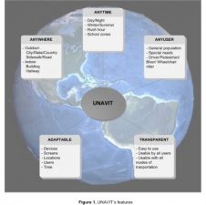
Indoor mapping is often associated with the rise in location-based services, but over the past few years there has been a growing demand for indoor mapping for a much wider range of use cases. In fact...
Mobile mapping is well past the tipping point and is about to go mainstream. Read this column by Felix Reinshagen to find out why. In his previous column about the future of indoor mobile mapping, Fel...

GNSS… it’s almost impossible to run a modern geo-related business without it. But what if a problem should occur? Whether in navigation, surveying or even agriculture, countless activities almost ...
Tall towers can bend and sway due to wind, cranes and other loads. Ideally, such movements should be around the main axis designed so that, in the absence of loads, the tower stands exactly vertical. ...
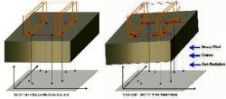
The construction of iconic towers such as the 828-metre high Burj Khalifa (formerly Burj Dubai), officially inaugurated on 4th January 2010 in Dubai, poses many challenges to surveyors. Tall towers ma...

Lead contractor Tarmac, along with its industry leading road planing business, NRP, racetrack specialist Dromo and project partner Topcon Positioning Group, combined expertise with innovative surveyi...

Heavy equipment represents a major capital cost for companies in industries such as construction and agriculture. In recent years Global Navigation Satellite System (GNSS) technology, which uses signa...

A keynote address at the XXV FIG Congress (Kuala Lumpur, Malaysia, 16-21 June) by Chris Rizos, IAG president, on ‘Opportunities & Challenges for the Surveying Industry in a Multi-system GNSS World�...

A short provision in the larger Islands Act bill passed by the Scottish Parliament in July 2018 now requires government mapmakers to put the Shetland Islands where it belongs. Tavish Scott, a politici...
In 1998 the Government of India Department of Science & Technology (DST) launched a National GPS Programme for Earthquake Hazard Assessment. The recent major earthquakes in the South East Asian region...
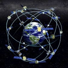
Receiver position is calculated from the position of satellites and the distances to them. Distance is calculated from the time a radio signal travels between satellite and receiver. But how do we kno...

RIEGL tested the performance of its topobathymetric airborne laser scanning system in a transition zone context along the French Mediterranean coast. Initially planned as a UAV survey, tests were cond...
This site uses cookies. By continuing to use this website, you agree to our Cookies Policy. Agree