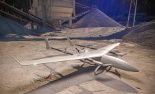
Remote sensing is all about gathering information on the earth using techniques that are ‘at a distance’ rather than touching the earth. Generally speaking remote sensing produces either point cloud data or imagery. The data is further processed using [geographical information systems] as part of [cartography].

Often Remote Sensing is differentiated by the type of platform or sensor used. Platforms can range from satellites through aircraft and drones to cars and ships. From a sensor perspective, Remote Sensing is a broad field that encompasses techniques such as [photogrammetry] and [lidar] but also [echosounding]. Often a form of ground truthing is required to transform the Remotely Sensed data into comprehensible products.

Downtown Dublin as a Lidar point cloud

Downtown Dublin as a Lidar point cloud

A dense annotated ground-truth Lidar dataset of the city of Dublin is the first of its kind regarding the accuracy, density and diversity of classes. The hierarchical labels offer excellent potential ...

5 Ways a Drone Can Benefit Your Construction Company

5 Ways a Drone Can Benefit Your Construction Company

The presence of drones for aerial mapping on construction sites is steadily growing. This is mostly due to the benefits of drones and how they help ensure construction projects go according to plan. T...

Night-time mobile mapping of road surface luminance

Night-time mobile mapping of road surface luminance

A new measurement system is being developed to evaluate night-time road lighting and safety conditions based on luminance-calibrated 3D point cloud data. This new approach integrates imaging photometr...

Smart Parking in Megacities

Smart Parking in Megacities

Did you know that you can waste a week or more per year hunting for a parking space in busy cities? Smart parking apps offer a much-needed answer to the problem nowadays – and mobile mapping point c...

The Age of Mobile Mapping

The Age of Mobile Mapping

Looking back over the past 30 years, it’s hard to believe just how far we’ve come in such a relatively short space of time. Geomatics students in the mid-1980s were exposed to GPS test satellites,...

Laser scanning of damaged historical icons

Laser scanning of damaged historical icons

How does the size of the site and the surveying aim affect the need for terrestrial laser scanning equipment? This article explains more, illustrated by four examples of projects to document historica...

6 Facts You Need to Know About 3D Reality Capture

6 Facts You Need to Know About 3D Reality Capture

Whether you are a savvy user or new to 3D reality capture, these six facts from Jürgen Mayer, president of Hexagon Geosystems’ Reality Capture Division, are sure to set you thinking about new appli...

Abseiling with a Handheld Scanner

Abseiling with a Handheld Scanner

Look up at Manchester’s skyline and it’s easy to see that this is a city undergoing a vast amount of development and construction, especially in the city centre. However, this can bring its own se...

Updating the Cadastre in Ecuador

Updating the Cadastre in Ecuador

Photogrammetry and Lidar were used together in Ecuador to detect irrigation and drainage canals for a project aiming to improve irrigation methods and create the related land registry. The integration...

Geospatial Data in Support of 3D Cadastre

Geospatial Data in Support of 3D Cadastre

The urbanization trend is leading to an increasing number of people living in cities, thus also placing new demands on cadastral registration. To be able to register the complex infrastructures and bu...