ESRI Ships ArcGIS 9.0.1
ESRI (CA, USA) has released ArcGIS 9.0.1, the latest version of its integrated collection of GIS software products. The release extends the supported platforms for ArcGIS Server, ArcGIS Engine and...
ESRI (CA, USA) has released ArcGIS 9.0.1, the latest version of its integrated collection of GIS software products. The release extends the supported platforms for ArcGIS Server, ArcGIS Engine and...
Esri has announced major changes to ArcGIS for Developers, providing an enhanced mapping experience that is more accessible and affordable. These changes include a pay-as-you-go plan for all of Esri's location-based...

Arkadiusz Szadkowski is senior business development manager of reality mapping, imagery & remote sensing at Esri. He is passionate about leading the change towards 3D GIS and bridging the gap...

Both vertical and oblique aerial images have their own advantages, making them valuable in different reality mapping applications. So how can you choose between the two? This comparison will help...
The TatukGIS Developer Kernel (DK) plays a key role in the Topoflight software suite (Missionplanner for optimal flight paths, and Navigator for precise data acquisition). In the realm of vast...
Whenever new objects have to be created, be it on or below the land and water, construction plays a role. The construction process often starts with surveying, either [marine surveying]...

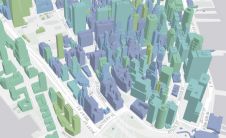
In a groundbreaking collaboration, Genesys International and Survey of India (SOI) have formed a strategic alliance to create digital twins of major cities and towns. This partnership is aimed at...

Intergeo 2023 was an electrifying three-day event in Berlin, transforming the city into the global geospatial capital. From 10-12 October, professionals from across the globe convened for the world’s premier...
TerraGo Technologies’ Publisher for ArcGIS v6 software is now available. This version of TerraGo geospatial collaboration software allows the Esri community to produce TerraGo GeoPDF maps and imagery for users...
Esri has released the ArcGIS Runtime Software Development Kit (SDK) for the Android platform. Available at no cost from the Esri Resource Center, ArcGIS Runtime SDK for Android enables organisations...
This site uses cookies. By continuing to use this website, you agree to our Cookies Policy. Agree