3D Building Library for Autodesk Users
CyberCity 3D, California, USA, has launched a new service on its website for users of Autodesk software which provides high-resolution, off-the shelf 3D city models. This new service provides a...
CyberCity 3D, California, USA, has launched a new service on its website for users of Autodesk software which provides high-resolution, off-the shelf 3D city models. This new service provides a...

Increasing public awareness, opportunities for industry change and predictions for the future! Hayley Tear, Robin Waters and Stephen Booth report on the highlights of another successful AGI GeoCommunity conference. Last...

Diversified Business Communications UK has announced the launch of GEO Business, a major new geospatial event incorporating an international trade exhibition, a conference and a hands-on workshop and demonstration programme....
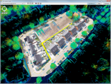
Orbit GeoSpatial Technologies, Belgium, has announced the availability of its completely re-engineered UAS mapping software solution. Peter Bonne, vice-president business development and senior product manager at Orbit GT, described the...

Charles has been Esri UK’s chief technology officer since 2008. He is committed to ‘reducing barriers’ to the use of geospatial information. Robin Waters met Charles at the bar after...

Carlson Software, USA, has announced that the company is introducing three new modules, Carlson GeoTech, Carlson CADnet, and Carlson Trench, as part of the 2014 release. While these products offer...
Topcon Positioning Group, USA, announces a multitude of new features and enhanced functionality to the entire MAGNET suite of connected workflow software. The MAGNET suite includes solutions for the field...
Modernising Land Agencies Budgetary Approach In collaboration with FIG together with Kadaster International (The Netherlands) and Lantmäteriet (Sweden), key partners and stakeholders, GLTN has embarked on a process to develop...
GEO Business, the brand new geospatial event for everyone involved in the gathering, storing, processing and delivering of geospatial information has announced a Call for Papers. Organised in collaboration with...

Topcon Positioning Group has announced the IS-310 imaging layout station – an advanced imaging and measurement system designed to increase Building Information Modelling (BIM) productivity in the construction layout and...
This site uses cookies. By continuing to use this website, you agree to our Cookies Policy. Agree