David Monetti
David Monetti holds a DI from the TU Vienna. He is currently CEO at Skyability GmbH, a drone service provider based in Austria. He manages daily business and research projects...

David Monetti holds a DI from the TU Vienna. He is currently CEO at Skyability GmbH, a drone service provider based in Austria. He manages daily business and research projects...
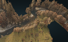
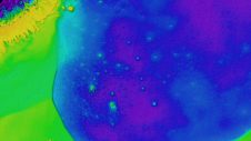
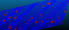
The monitoring of submerged deadwood and vegetation is gaining increased attention due to their socio-economic and ecological importance. Deadwood acts as an important underwater habitat but also poses a threat...
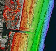
Woolpert has been granted a patent by the United States Patent and Trademark Office for its ‘Airborne Topo-Bathy Lidar System and Methods Thereof’. A Lidar sensor system was developed by...

This specially selected series of articles illustrates how geomatics plays a key role in protecting and preserving the environment. Geospatial data forms an important part of the toolkit of researchers...
Cartography is about describing the world in the form of maps and diagrams. Classic cartography produces paper maps but nowadays this field also encompasses Geographical Information Systems and the products...
Teledyne Optech and Teledyne CARIS have united to form Teledyne Geospatial in response to evolving marketplace needs. Under the Teledyne Imaging group, the harmony between the two business units is...
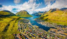
Crewless aerial mapping was recently chosen when surveying the Faroe Islands. For the small team, labour savings provided one advantage of a UAV-based approach. Another benefit was that clear skies...
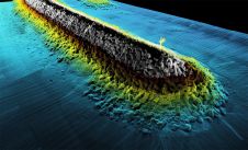
Hydrospatial could be described as that portion of geospatial knowledge infrastructure that addresses the hydrosphere, and hydrospatial technologies support navigation, economic development, stability, security and defence, resilience and scientific research....
Time issues associated with processing point clouds are hugely frustrating, but they are nothing new. And the shifting boundaries mean that we’re destined to forever play the waiting game, according...
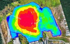
Hydrographic surveying in lakes and canal regions has not been an easy job in the past. Due to a lack of professional and portable surveying equipment and mobile platforms, the...
This site uses cookies. By continuing to use this website, you agree to our Cookies Policy. Agree