New UN organization to highlight the value of geodesy
The brand-new United Nations Global Geodetic Centre of Excellence (UN-GGCE) is now operational at the United Nations campus in Bonn, Germany. Nicholas Brown, head of office of the UN-GGCE, is...

The brand-new United Nations Global Geodetic Centre of Excellence (UN-GGCE) is now operational at the United Nations campus in Bonn, Germany. Nicholas Brown, head of office of the UN-GGCE, is...
Topcon Positioning Systems has presented the latest addition to its HiPer family of global navigation satellite system (GNSS) receivers. The HiPer CR is a compact and lightweight GNSS receiver designed...

Harxon demonstrated its dedication to innovation at Intergeo 2023 by introducing two products designed to advance high-accuracy positioning within the geospatial industry: the Survey GNSS Antenna (HX-CSX600A) and the Helix...

A global audience of geospatial professionals witnessed the presentation of the JOUAV VTOL Hangar, a groundbreaking development in the field of vertical take-off and landing (VTOL) drones, at Intergeo 2023....

On 24 January 2023, the European Union declared the Galileo High Accuracy Service (HAS) operational for testing, and it is scheduled to become fully operational in 2024. This free signal adds...

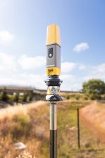
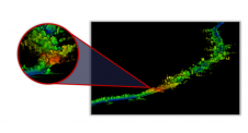
The application of visual positioning technology to geological mapping is of great significance given its current widespread use and huge potential in multiple industries. It is a significant exploration for combining GNSS, IMU, and cameras for a surveying and mapping job. Visual positioning technology can break through the bottlenecks of traditional mapping scenarios. It makes geological mapping more accurate, efficient, and diverse. The vRTK is the first GNSS receiver with dual cameras. Let's see what surprises it will bring to us in the land survey! Visual Positioning Technology is a Major Breakthrough in GNSS Receiver Development The GNSS Receiver has evolved over the years. Through continuous product improvements, a highly integrated RTK receiver with inertial...
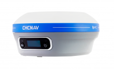
CHC Navigation (CHCNAV) has announced the availability of the i83 GNSS receiver, a new and innovative addition to its premium GNSS receiver series for surveying, mapping and construction professionals. The...

What is the current state of GNSS, from both a constellation, augmentation and receiver perspective? Spoiler alert: it is more of an evolution than a revolution! It is almost impossible...
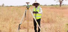
By applying Beidou technology, ComNav Technology has yielded fruitful results in African land mapping, continuous operating reference station (CORS) construction, precision agriculture and other fields over the past decade. Every...
We rarely stop to appreciate just how complex modern surveying technology is. Surveyors use the most advanced physics, with decades of experience, in every component. Consequently, in such complex systems,...
This site uses cookies. By continuing to use this website, you agree to our Cookies Policy. Agree