Building Information System
In Lombardy (Italy) one has started a project on risk-assessment of buildings of historical-architectural importance. For this purpose a Building Information System (BIS) has been created, based on archived and...
In Lombardy (Italy) one has started a project on risk-assessment of buildings of historical-architectural importance. For this purpose a Building Information System (BIS) has been created, based on archived and...
Two important articles, both from Canada, in the present issue of GIM International are on imaging radar. One article focuses on Canada’s second SAR earth observation satellite: RADARSAT-2. This satellite...
The first permanent earth observation satellite, today known as Landsat 1, was launched 33 years ago. With a ground resolution of 80 metres, the Landsat Multispectral Scanner images provided an...
The 4th International Symposium on Digital Earth was held in Tokyo, Japan from 28th to 31st March 2005 (see review 'Digital Earth Facing Challenges' July 2005). The head of the...
The 4th International Symposium on Digital Earth was held in Tokyo, Japan from 28th to 31st March 2005 (see review 'Digital Earth Facing Challenges' July 2005). The head of the...
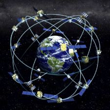
Receiver position is calculated from the position of satellites and the distances to them. Distance is calculated from the time a radio signal travels between satellite and receiver. But how...
QuickBird imagery offers the highest spatial resolution so far available from a commercial satellite. Resolutions as low as 60cm, combined with high positioning accuracy, make it well suited for mapping...
Surveyors working on busy roads are constantly subjected to close misses from passing traffic; it can be worse. Helicopter photogrammetry is a survey technique designed to prevent fatalities. A complete,...
The collection of Ground Control Points (GCP) for block adjustment is a costly and time-consuming operation. Onboard GPS enables a reduction in the number of GCPs without loss of accuracy....
Jena-Optronik GmbH (Germany) has announces the new Jena Airborne Scanner JAS 150, a second generation digital sensor with enhanced flexibility and reliability. Developed for photogrammetry, mapping and remote sensing of...
This site uses cookies. By continuing to use this website, you agree to our Cookies Policy. Agree