Korec Releases New Versions Of Fastmap Software
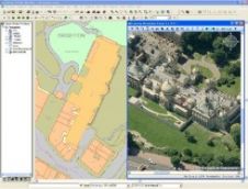
Korec is delighted to announce that Version 6 of their main fastMAP mapping products are now available. New features in version 6 of KOREC's best selling GIS data capture and...
Korec is delighted to announce that Version 6 of their main fastMAP mapping products are now available. New features in version 6 of KOREC's best selling GIS data capture and...
With the growing interest in (inter)national road safety programmes comes a need for documentation of road systems for safety analysis and traffic-accident reconstruction studies. This requires reliable, accurate and timely...
The GeoInformation Group (United Kingdom), publishers of Cities Revealed aerial photography, has captured aerial imagery of Belfast at 12.5cm resolution. This high-resolution aerial imagery dataset was captured on 16th September...
For the first time in Iran, the National Cartographic Center of Iran has printed a 1/5000000 scale map of the country suitable for use by the blind and the visually...
The National Geospatial-Intelligence Agency (NGA) will use DigitalGlobe CitySphere to access imagery of 200 of the world’s major metropolitan areas. CitySphere is an off-the-shelf collection of orthorectified color imagery provided...
Rotterdam is Europe’s largest logistical and industrial hub and its port is the gateway to a European market of 450 million consumers. It is accessed by five competing modes: road,...
Cadcorp (United Kingdom) has announced a new, free application for viewing Pictometry oblique view imagery within Cadcorp SIS – Spatial Information System. The new Cadcorp SIS Pictometry Viewer, developed by...
The company Pictometry has patented an aerial imagery technology based on acquiring oblique digital images and primarily developed as an imagery visualisation tool. Oblique: I know what that is, but...
Sokkia (Japan) has released the SRX, a new line-up of robotic total stations. SRX models are available with an angular precision varying from 1.5 to 15mgon (0.5” to 5”). New...
Topcon Europe Positioning and TSD have announced a new family of automated paving control systems. The three new systems: ReadyPave, MasterPave and AutoPave; all feature easy-to-use, automated controls with millimetre...
This site uses cookies. By continuing to use this website, you agree to our Cookies Policy. Agree