Leica HDS 3000 in the Lab
To the user the terrestrial laser scanner (TLS) is a black box; measurement procedure and data processing are treated as classified. Vendor provided technical specifications are reliable but may be...
To the user the terrestrial laser scanner (TLS) is a black box; measurement procedure and data processing are treated as classified. Vendor provided technical specifications are reliable but may be...
Image-based modelling is still the most widely used approach in building documentation and 3D investigations, but panoramic camera laser scanners are gaining in importance. They offer large fields of view,...
To facilitate acceptance of new digital technologies in aerial imaging and mapping, the US Geological Survey (USGS) and its partners have launched a Quality Assurance (QA) Plan for Digital Aerial...
Digital airborne imaging has grown in importance over recent years. Large-format digital cameras can fully compete with analogue mapping cameras, and for some applications their performance is better. However, methods...
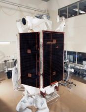
Ball Aerospace & Technologies Corp., ITT Corporation and DigitalGlobe have announced delivery of its WorldView-1 satellite to Vandenberg Air Force Base in California for its scheduled launch on Tuesday, 18th...
China now has five navigation-and-positioning satellites, the launch of the fifth Beidou satellite took place in April. The system provides regional coverage of China and surrounds. It is named Beidou...
Founded in 1978 in Sunnyvale, California, US, Trimble provides positioning solutions that enable professionals in many areas to improve their work processes. As well as utilising positioning technologies such as...
GPS is good for perhaps 70% of surveying needs. Inertial Navigation is the forgotten friend of GPS. Traditionally complex and expensive, Inertial Navigation has become competitive, easy-to-use and cost-effective. Need...
Year after year Intergeo demonstrates how exceptionally flourishing is the geo(infor)matics business. Geo(infor)matics is all about improving human understanding of the earth, enabling management and staff in both public and...

DigitalGlobe (CO, USA) has successful launched and deployed WorldView-1. The satellite launched at approximately 11:35 AM PDT on a Boeing Delta II 7920 rocket from Vandenberg Air Force Base in...
This site uses cookies. By continuing to use this website, you agree to our Cookies Policy. Agree