FARO Releases Zone 2D
FARO has announced the release of FARO Zone 2D, a completely new diagramming software for law enforcement, fire service, and insurance professionals. FARO Zone 2D is the next generation diagramming software...
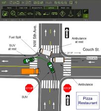
FARO has announced the release of FARO Zone 2D, a completely new diagramming software for law enforcement, fire service, and insurance professionals. FARO Zone 2D is the next generation diagramming software...
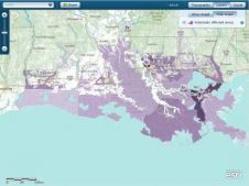
Esri has created a map showing parishes within the Federal Emergency Management Agency (FEMA) 100-year flood zone in Louisiana (USA). FEMA is a government body supporting citizens and first responders...
Fugro has tested a multi-sensor approach to balance growing data needs with limited agency budgets. Coastal mapping programmes are quickly becoming a priority for government agencies across the globe. The desire...
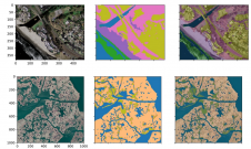
A new paper published in 'Scientific Data' presents the ‘CoastTrain’ dataset, a collection of orthomosaic and satellite images of coastal environments along with corresponding labels. The dataset includes 1.2 billion...
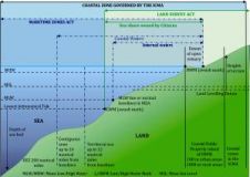
Since time immemorial the seashore has played an evolving but important role in society. In South Africa, the interface between rights in the land and the seashore has been the...
Telcontar (CA, USA) has announced the Telcontar Developer Zone, an online service that enables prototyping and development of location-enabled applications. The service allows access to software, sample code, documentation and...
The ‘Umi-no-Chizu’ (‘Map of the Sea’) project will use aerial measurement to map 90% of Japan’s shallow coastal waters (to a depth of 20m). This is a joint project by...

In this case study, QuestUAV describes the use of UAV photography and photogrammetry to measure long-term erosion of the coast of northeast England. The British Geological Survey states that across...
This site uses cookies. By continuing to use this website, you agree to our Cookies Policy. Agree