GEO Business 2024: unlocking geospatial innovation at ExCeL London
GEO Business, the UK’s premier geospatial event, is celebrating its tenth anniversary when it returns to ExCeL London on 5 and 6 June 2024. This edition promises to be the...

GEO Business, the UK’s premier geospatial event, is celebrating its tenth anniversary when it returns to ExCeL London on 5 and 6 June 2024. This edition promises to be the...

In the ever-evolving landscape of climate change, geospatial science emerges as a key player in navigating the complexities of our transforming world. The European Association of Aerial Surveying Industries (EAASI)...
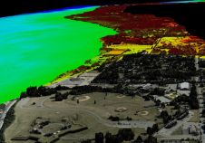
An integrated approach towards coastal zone management requires relevant, credible and reliable (geo-)data. However, the legends of geo-information covering coastal zones vary so much between the various European countries that...

RIEGL has announced the launch of two innovative topobathymetric scanners. These advancements mark a shift towards enhanced efficiency and precision in data collection across land and water interfaces. The RIEGL...

Global reference systems such as the International Terrestrial Reference Frame provide the foundation for determining positions on Earth and in space, as well as for reliably quantifying our planet’s changes...

The Woolpert-GDS Joint Venture (JV) has been contracted to acquire topographic and bathymetric lidar data of the Caribbean island Saint Lucia’s entire landmass and coastal zone. The contract was signed...
“Think big for coastal mapping” is the foremost advice that Don Ventura of Teledyne Geospatial would impress upon agencies interested in bathymetric Lidar. “It’s a matter of efficiency of scale.”...
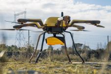
YellowScan, a familiar name in the mapping and land surveying realm, is making a noteworthy entrance in the hydrographic sector with the introduction of its pioneering UAV-based bathymetric Lidar solution....
This site uses cookies. By continuing to use this website, you agree to our Cookies Policy. Agree