Joël van Cranenbroeck
Joël van Cranenbroeck is a geodesist, founder of CGEOS Creative Geosensing SRL and scientific advisor at the University of Liège, Belgium. He has extensive experience at institutions like the National...

Joël van Cranenbroeck is a geodesist, founder of CGEOS Creative Geosensing SRL and scientific advisor at the University of Liège, Belgium. He has extensive experience at institutions like the National...

Blue Marble Geographic’s flagship software, Global Mapper Pro, is an all-in-one GIS package for analysing and processing vector, terrain, image and point cloud data. Compatible with over 380 different file...
Besides the surveying hardware & software and the intricacies of BIM and data exchange, this article explores broader aspects of digitalization in the construction industry. How are they affecting the...

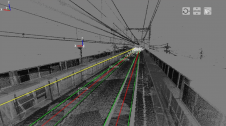
Bentley Systems and WSB are collaborating to promote the use of infrastructure digital twins in civil infrastructure projects. WSB, an American design and consulting firm, has launched a digital construction...
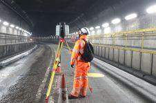
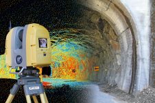
Digitalization is changing the construction industry faster than expected. But will we ever see paperless construction sites? Digitalization is changing the construction industry faster than expected. Automation, additional sensors and...

Both vertical and oblique aerial images have their own advantages, making them valuable in different reality mapping applications. So how can you choose between the two? This comparison will help...
It is estimated that the global construction industry will grow to US$10.3 trillion by 2020. Arguably, the development and investment in ever-more innovative digital tools will be key in enabling that...
UK Construction Week (UKCW) brings together all stakeholders within the built environment across design, build and supply; promoting innovation, projects, learning and networking.
Nippon Insiek and SITECO Informatica have announced the provision of an advanced road-scanner system to Japan’s leading railway company, JR East, to support JR East’s response to the quest for...

In the rapidly evolving landscape of geospatial technology, the annual Trimble Dimensions gathering is a dependable beacon for the surveying and mapping fields, providing a panoramic view of the current...
This site uses cookies. By continuing to use this website, you agree to our Cookies Policy. Agree