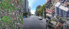
MAPublisher 7.6 for Adobe Illustrator
Avenza Systems Inc. (Canada) has released MAPublisher 7.6 for Adobe Illustrator, the latest version of this mapmaking software used to produce high quality maps from GIS data. MAPublisher 7.6 for...
Surrey Satellite Technology Ltd (SSTL) is to launch two new enhanced Disaster Monitoring Constellation (DMC) satellites in the fourth quarter of 2008. Deimos-1, which was built for Deimos SL (Spain)...
Intermap Technologies is to change its organisation. Total employee headcount has been decreased by 17%, including a significant reduction at the executive level. The restructuring follows Intermap's completion of the...
Optech has acquired the operations and assets of DiMAC, inventor of the patented DiMAC true Forward Motion Compensation technology for over five years. DiMAC has been providing large and medium-format...
Intermap Technologies has signed an agreement valued at USD1.2 million to provide a leading wireless telecommunications company with 3D digital terrain maps for all of Germany and significant portions of...
Avenza Systems Inc. (Canada) have released MAPublisher 7.1 for Adobe Illustrator CS and CS2, a mapmaking software used to produce high quality maps from GIS data. Version 7.1 is a...
In co-production, GAF AG and its subsidiary, Euromap GmbH (Germany), have extended the availability of the successful IRS orthophoto mosaic "Euro-Maps" from Germany, Austria and Switzerland to Italy. Euro-Maps is...
DigitalGlobe (CO, USA) has introduced DigitalGlobe CitySphere, a product aimed at helping mappers, planners and GIS specialists to improve all geospatial applications with the rapid delivery of current, repeatable, high-resolution...
Topcon Positioning Group has announced the MR-2 modular GNSS receiver. The system combines all current and planned constellation tracking with a comprehensive set of communication interfaces to service any precision...
52°North, the German initiative for geospatial open source software, recently held its annual Sensor Web Workshop at the University of Münster's Insitute for Geoinformatics. Sensor Web enthusiasts and practitioners met...
This site uses cookies. By continuing to use this website, you agree to our Cookies Policy. Agree