How Geospatial Technology is Vital for Exploring Mars
Courtesy of the USGS Astrogeology Science Center, NASA’s Perseverance rover was equipped with some of the most precise maps of Mars ever created when it landed on the planet in...
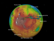
Courtesy of the USGS Astrogeology Science Center, NASA’s Perseverance rover was equipped with some of the most precise maps of Mars ever created when it landed on the planet in...
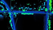
Both vehicle-based and UAV-based Lidar systems from Routescene have been used in a survey to prepare for the replacement of aging power lines in Oliver, British Columbia, Canada. Electricity distribution...
UP42 and SI Imaging Services (SIIS) of Daejeon, South Korea, have signed an agreement to make imagery from the Kompsat satellites available on the UP42 marketplace and developer platform. The...
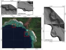
The accuracy of coastline data in Indonesia could be much improved by making use of Lidar bathymetry technology. In this article, the authors describe how Lidar bathymetry survey techniques were...

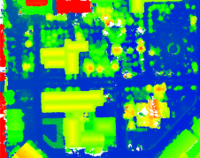
As the demand for elevation data continues to rise, it is important that users match the level of reliability, accuracy and resolution of the data to their specific application to...
DJI recently introduced the P4 multispectral, a high-precision unmanned aerial vehicle (UAV or ‘drone’) which exploits the integration of multispectral cameras to facilitate agricultural and environmental monitoring applications. Therefore, imagery...
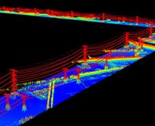
With the rapid development of civil construction and the increasing demand for electricity in recent years, the market segment of power grid construction has grown significantly. Meanwhile, how to efficiently...
Lidar technology is synonymous with 3D point clouds. To get the most out of 3D point cloud data, it is necessary to step back and continually consider the newest trends...

Remote sensing projects often begin with the question: 'Should I use aerial imagery or satellite imagery?'. During long-term projects, this question may arise again, particularly when unforeseen circumstances change the...
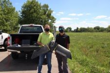
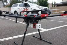
Ohio-based energy provider Dayton Power & Light is employing a fleet of senseFly eBee X fixed-wing drones to improve its large-scale data collection and mapping capacity in partnership with Sinclair...
This site uses cookies. By continuing to use this website, you agree to our Cookies Policy. Agree