Accurate footprints from Antarctica
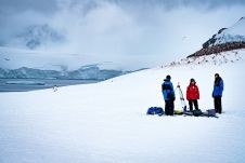
Remote sensing surveys in Antarctica based on unmanned aerial vehicles (UAVs or ‘drones’) have become a very important approach for a wide range of studies. Mapping free-from-ice-and-snow terrain and monitoring...
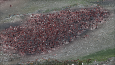
Remote sensing surveys in Antarctica based on unmanned aerial vehicles (UAVs or ‘drones’) have become a very important approach for a wide range of studies. Mapping free-from-ice-and-snow terrain and monitoring...
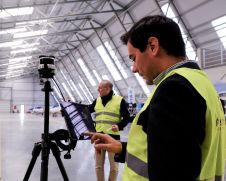
The Dutch startup Aerial Precision recently demonstrated its first two sensors with integrated artificial intelligence software. Over the past few years, the company’s innovation efforts have resulted in products that...
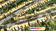
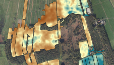
Improved understanding of the amount of solar energy that could be gathered directly from roofs can support the complex task of transitioning existing low-density residential areas to renewable energies. A...
Topodrone, a Swiss-based designer and manufacturer of high-precision Lidar equipment for installation on drones, vehicles and backpacks, has launched Aquamapper, a UAV-based solution for bathymetric surveying and marine construction. The...
The Earth sciences sector is rapidly adopting UAVs. These two studies have explored combining a gamma-ray spectrometer with a drone to map soil properties. In the Earth sciences sector, sensors...
Making their European debut, LP360 and the all-new TrueView 655/660 will be exhibited at Intergeo 2022. The TrueView 655/660 is GeoCue’s third-generation RIEGL integration built with the miniVUX-3UAV and triple...
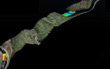
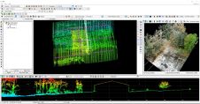
A project in Aotearoa/New Zealand is combining the use of high-quality DEMs from satellite photogrammetric mapping (SPM) with Lidar technologies to model hazards such as snow avalanches. The resulting topographic...
Attendees of YellowScan's recent Lidar for Drone 2022 Conference headed home with a backpack full of inspiration, according to Wim van Wegen. A relaxed vibe, sunny weather with summer temperatures,...
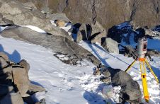
Capturing and measuring the environment in the Arctic and Antarctic is a particularly challenging job. The area of interest is often covered by a thick blanket of snow and ice,...
AIRWORKS 2022 -DJI
This site uses cookies. By continuing to use this website, you agree to our Cookies Policy. Agree