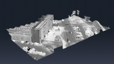
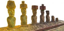
Found 465 results
Sort by

Colourized point clouds from photogrammetry

Since the explosion of Lidar over the past two decades, the use of point clouds in aerial mapping applications has become common these days. However, Lidar is not without its challenges. This article explores how colourized point clouds from photogrammetry can offer a value-adding alternative. Since the explosion of Lidar over the past two decades, the use of point clouds in aerial mapping applications has become common these days. However, Lidar is not without its...

Read more

Claudio Persello

Claudio Persello is an adjunct professor at the Faculty of Geo-Information Science and Earth Observation (ITC) of the University of Twente. His main research interests are in the context of...

Read more

Remote sensing for land administration

From drones and satellites to airborne-based sensors and Lidar, advances in remote sensing and geospatial information science are driving the development of innovative methods for data acquisition, processing and maintenance....

Read more