Global Mapping
We are a company that provides digital cartography solutions designed to meet our clients’ needs and obtain levels of precision that guarantee their trust in us. To achieve this, we...
We are a company that provides digital cartography solutions designed to meet our clients’ needs and obtain levels of precision that guarantee their trust in us. To achieve this, we...
Whether based on Lidar, photogrammetry, radar, sonar or other remote sensors, systems for geodata acquisition create millions or even billions of 3D points. To be useful, the data needs to...
The Australian Transport Safety Bureau (ATSB) has awarded Fugro a contract that will see the deployment of its specialist vessel, equipment and expertise in the underwater search for the missing...
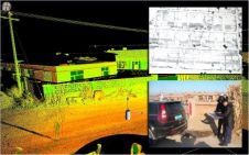
Collecting and processing point clouds has been trending topic in the geospatial sector over the past few years. This article focuses on point cloud processing software aimed at creating DEMs...
This year’s HxGN Live, Hexagon Metrology’s annual user conference, was once again held in Las Vegas, USA, from 2-6 June. Its maxim: ‘Great Stories Start Here’. From a geomatics point...

These are exciting times in the geomatics industry. Innovative solutions are being developed, integration is the main keyword and the big players are acquiring smaller companies that add a new...

Geo-matching.com has recently added rental companies and dealers to its overview of products and solutions. Besides detailed information about the manufacturers of products and brands, Geo-matching.com users can now also...
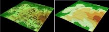
Knowing the volume of material present in a gravel quarry can make the difference between profit and loss. A gravel quarry in Hartheim am Rhein, southwest Germany, is partially covered...
Seafloor Systems has announced the appointment of Mauro Romani as sales support engineer for the Latin American market. Mr Romani, who previously served as a geotechnical equipment specialist for Golder Associates...

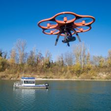
The period where exponential growth remains unnoticed following the inception of innovation is classified as ‘deception’. The year 1849 inaugurated the birth of the unmanned aerial vehicle (UAV or ‘drone’),...
This site uses cookies. By continuing to use this website, you agree to our Cookies Policy. Agree