Yuneec Launches RTK Variant of H520 Hexacopter
UAV manufacturer Yuneec has released a new version of its commercial hexacopter platform with an integrated RTK unit from Swiss firm Fixposition. The H520 RTK is capable of 1cm +...
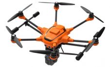
UAV manufacturer Yuneec has released a new version of its commercial hexacopter platform with an integrated RTK unit from Swiss firm Fixposition. The H520 RTK is capable of 1cm +...

At the end of 2018, China’s Satellite Navigation Office announced that the country’s GNSS (called BeiDou or ‘BDS’) is now available as a global service. Originally, worldwide coverage was not...
AEE Aviation, a global leader in drone and camera technology, has announced the expansion of their partnership to include the artificial intelligence (AI) capabilities of ModalAI. The two companies are...

Septentrio, a leader in high-precision GNSS technology, is teaming up with Point One Navigation, a provider of precise location as a service, for autonomous vehicle demonstrations during CES 2019 in...
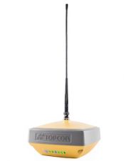
The HiPer VR is compact, light and packed with the most advanced GNSS technology in a design built to withstand the harshest field environments. Using Topcon’s advanced GNSS chipset with...
UAS (Unmanned Airborne Systems) are rapidly becoming a valuable source of data for inspection, surveillance, mapping and 3D modelling projects. Investment in the commercial UAS industry - estimated to increase...

A short provision in the larger Islands Act bill passed by the Scottish Parliament in July 2018 now requires government mapmakers to put the Shetland Islands where it belongs. Tavish...

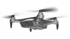
DJI, a world leader in civilian drones and aerial imaging technology, has announced the global rollout of the Phantom 4 RTK, a high-precision aerial survey drone that combines centimetre-level navigation...

Ordnance Survey (OS) has just updated its geodetic infrastructure. Mark Greaves, Lead Consultant at Geodesy, describes these developments and takes a look at shorter and longer-term geodetic issues for surveyors....

Trimble has announced that Galileo and BeiDou observation data will be included with Trimble VRS Now subscriptions in North America. Powered by the Trimble Pivot Platform GNSS Real-time network software, the...
This site uses cookies. By continuing to use this website, you agree to our Cookies Policy. Agree