ComNav Technology Upgrades GNSS Receivers
ComNav Technology has announced a global upgrade of the T300 and T300 Plus GNSS receiver, including the upgrade to the new GNSS K8 platform on both receivers and the replacement...
ComNav Technology has announced a global upgrade of the T300 and T300 Plus GNSS receiver, including the upgrade to the new GNSS K8 platform on both receivers and the replacement...
We rarely stop to appreciate just how complex modern surveying technology is. Surveyors use the most advanced physics, with decades of experience, in every component. Consequently, in such complex systems,...

Topcon Positioning Group has announced an expansion of the Topnet Live Global Navigation Satellite Systems (GNSS) network of correction solutions to support today’s work environments. The newly expanded global network...
Tallysman Wireless has announced the addition of its first full-band GNSS antenna to its industry-leading line of Helical antennas. The full-band GNSS HC990E embedded helical antenna is designed for precise...

During the early days of Global Positioning System (GPS) technology in the 1980s and 1990s, surveyors had to chase satellite geometry and spend long hours collecting data in order to...

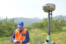
The latest GNSS technologies from CHCNAV have been used in combination with vocational training on the island of Sumatra to improve the productivity of surveying activities and hence contribute to...

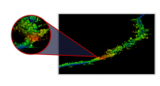
Time issues associated with processing point clouds are hugely frustrating, but they are nothing new. And the shifting boundaries mean that we’re destined to forever play the waiting game, according...

Tallysman Wireless has announced the addition of four new embedded VeroStar products to its line of antennas. According to the Canada-based antenna manufacturer, the compact and light embedded VeroStar models...

The Harxon HX-CVX600A offers full support for reliable and consistent tracking of satellite signals including GPS, GLONASS, Galileo, Beidou, QZSS, IRNSS, SBAS as well as L-band correction services. It has...
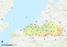
A continuously operating reference station (CORS) provides GNSS data to support very accurate 3D positioning and additional geophysical applications. Flemish Positioning Services (FLEPOS) is the real-time global navigation satellite system...
This site uses cookies. By continuing to use this website, you agree to our Cookies Policy. Agree