Capturing the Arctic and Antarctic
Capturing and measuring the environment in the Arctic and Antarctic is a particularly challenging job. The area of interest is often covered by a thick blanket of snow and ice,...
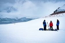
Capturing and measuring the environment in the Arctic and Antarctic is a particularly challenging job. The area of interest is often covered by a thick blanket of snow and ice,...
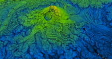
Lidar owes its growing popularity to the accuracy and high resolution with which it maps the environment. Continued technological advances are resulting in even better usability, reliability and sustainability, while...
The release of Android version 7.0 in 2016 allowed users to access raw data transmitted by the Global Navigation Satellite System (GNSS) for the first time. More recently, it has...
These inspiring articles all prove the versatility of the brilliant technology that is Lidar. Sensor miniaturization has made Lidar technology easier to integrate, enabling applications such as UAV-based and handheld...

Advanced Navigation has acquired Vai Photonics, a spin-out from the Australian National University (ANU) developing patented photonic sensors for precision navigation. Advanced Navigation is one of the world’s most ambitious...
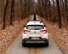
The Mosaic 51, a 360-degree mobile mapping camera, is now fully integrated with external GNSS to easily achieve real-time kinematic (RTK). Thanks to these extended capabilities, Mosaic’s solution offers centimetre-level...
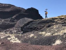
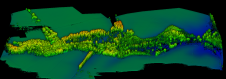
NASA researchers and their industry partners have developed a remote sensing mapping system to aid explorers in the most isolated wilderness imaginable: the airless wastes at the South Pole of...
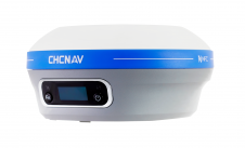
CHC Navigation (CHCNAV) has announced the availability of the i83 GNSS receiver, a new and innovative addition to its premium GNSS receiver series for surveying, mapping and construction professionals. The...
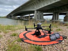
The use of a Phase One iXM-100 enabled EyeFly BV to fly closer to the Buggenum rail bridge in the Netherlands for the required annual bridge inspection. This achieved a resolution of close...
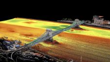
Two Hungarian companies designed a three-step data collection workflow to overcome the challenges in this urban surveying project in Hungary, which included the use of UAVs and remote-controlled boats for...
This site uses cookies. By continuing to use this website, you agree to our Cookies Policy. Agree