New UN organization to highlight the value of geodesy
The brand-new United Nations Global Geodetic Centre of Excellence (UN-GGCE) is now operational at the United Nations campus in Bonn, Germany. Nicholas Brown, head of office of the UN-GGCE, is...

The brand-new United Nations Global Geodetic Centre of Excellence (UN-GGCE) is now operational at the United Nations campus in Bonn, Germany. Nicholas Brown, head of office of the UN-GGCE, is...

Despite some uncertainty, there is renewed interest in drones, and remote sensing technologies are being embraced by smaller survey companies. Read these and other findings from our annual industry survey!...
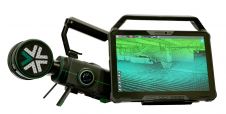
Exyn Technologies has unveiled Exyn Nexys, an innovative modular 3D mapping solution. Designed for professionals in the mining, construction, AEC and geospatial industries, Nexys aims to set a new standard...
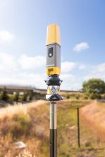
Topcon Positioning Systems has presented the latest addition to its HiPer family of global navigation satellite system (GNSS) receivers. The HiPer CR is a compact and lightweight GNSS receiver designed...
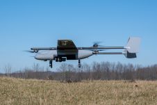
In a new strategic partnership, Inertial Labs' RESEPI Payload Lidar technology will be integrated into E38's advanced E455 drone platform. This collaboration marks a significant milestone in the utilization of...
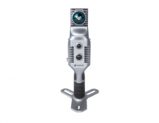
Stonex has launched a new SLAM solution for fast and efficient large-area surveys: the X70GO SLAM laser scanner. It combines mobile scanning with a stationary mode to scan with higher...

Founded in 2017, ZZCOMM technology of geospatial hardware and software solutions provides rapid and high-accurate geospatial data for BIM, mining AEC, survey and mapping industries, whether they are indoor, outdoor,...

GrabMaps is preparing to launch KartaCam 2, a crowdsourced mapping solution combining high-end imagery and AI capabilities to transform local expertise into effective navigation solutions. With the introduction of enhanced...
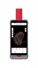
ComNav Technology has introduced its new handheld P6H. This advanced and rugged device is tailor-made for GIS data collection and outdoor operations. Featuring a GNSS high-precision positioning module, rugged IP67-rated...

Incorporating smart methodologies in cadastral surveying is improving the land acquisition system in Ghana. Traditional cadastral surveying is time-consuming and, if not planned out well, could cost a fortune to...
This site uses cookies. By continuing to use this website, you agree to our Cookies Policy. Agree