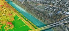
Hexagon’s Geospatial division has launched Luciad 2020, a significant update to its platform for building advanced location intelligence and real-time, situational awareness applications. Luciad 2020 delivers faster and more powerful 3D visualization and analysis capabilities. It also extends the portfolio with LuciadCPillar, an API for C++ and C# developers to incorporate advanced geospatial visualization and analysis into their applications. Hexagon’s Luciad portfolio allows developers to create powerful, high-performance applications that leverage data from any source for visualization and analysis in 2D and 3D. Combining static, dynamic and real-time data, including moving tracks, Luciad-powered applications support defence, aviation, infrastructure and...
(read more)