Using BIM data together with city models
An increasing number of cities are creating 3D city models to support visualization and simulations in the urban planning process. The 3D city models are often extended with planned buildings....
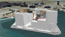
An increasing number of cities are creating 3D city models to support visualization and simulations in the urban planning process. The 3D city models are often extended with planned buildings....
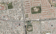
Due to the local region’s proneness to occasional wildfires, the Geomatics Division at the University of Cape Town, South Africa, has conducted research and project work around the theme of 3D...

Intergeo 2021 is returning as a physical event and will be held in Hannover from 21-23 September. There is a comprehensive safety strategy in place based on COVID-19 prevention rules;...
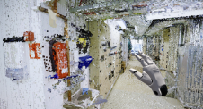
How can the dense point clouds that originate from 3D mapping be turned into useful game engine scenes? This article considers issues including point classification and segmentation, geometric accuracy and...
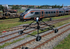
Nordic Unmanned has unveiled the Staaker BG-300 Railway Robot, an innovative solution that has the ability to operate both in the air and on the railway. A welcome innovation, since...
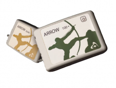
Eos Positioning Systems (Eos), the global manufacturer of Arrow Series GNSS receivers, has announced the release of two new GNSS receiver models: the Arrow Gold+ and Arrow 100+. These plus...
The mission: capturing 21 quarries in 60 days. Squeezed into that timeframe were planning and performing the UAV photogrammetry flights, editing the RAW images, processing the data, extracting the topography using Virtual Surveyor, and production of the orthophotos, Digital Surface Model (DSM), Digital Terrain Model (DTM) and contour maps for each site. The main client, a government institute, needed highly precise and reliable 3D models and maps fast, as well as data their engineers could work with in a CAD environment. “There was a lot of pressure because of the short timeline”, said Nuno Santos, owner and CEO of Aerisurvey, a Mangualde, Portugal-based company specialized in high-precision UAV surveying. Mapping 21 Quarries in 60 Days The mission was to capture 21 quarries in 60 days. Squeezed into that timeframe were planning and performing the UAV photogrammetry flights, editing the...
Time issues associated with processing point clouds are hugely frustrating, but they are nothing new. And the shifting boundaries mean that we’re destined to forever play the waiting game, according...

In view of the ongoing pandemic situation, ISPRS is organizing an extended digital edition of the XXIV Congress from 5-9 July this year, with all the features of an ISPRS...
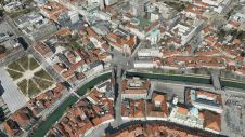
In orthophoto projects of dense urban areas, true orthophotos are preferred over traditional orthophotos because they put building roofs into the correct horizontal position. However, there is still a widespread...
This site uses cookies. By continuing to use this website, you agree to our Cookies Policy. Agree