Today and Tomorrow
The 4th International Conference and Exhibition Laser Scanning and Digital Aerial Photography was recently successfully held with the theme of ‘Today and Tomorrow’. More than 170 participants from twelve countries...
The 4th International Conference and Exhibition Laser Scanning and Digital Aerial Photography was recently successfully held with the theme of ‘Today and Tomorrow’. More than 170 participants from twelve countries...
‘Knowledge and Action for the Earth’ is the theme of Intergeo 2006, the annual geodesy and geo-information conference and trade-fair organised in association with the German Association of Surveying (DVW)...
The Intergeo congress and trade-fair has now been held a dozen times and the event once again this year demonstrated an exceptionally flourishing geomatics business. Geomatics is all about improving...
3D Laser Mapping, a company specialised in laser-mapping systems, operates from headquarters near Nottingham in the United Kingdom. In addition to airborne Lidar, 3D Laser Mapping has pioneered terrestrial Lidar...
3D Laser Mapping (UK) has launched StreetMapper, a mobile system for the capture of detailed three dimensional map data. The vehicle-mounted system uses a series of lasers to measure the...
This issue of GIM International provides an extensive product survey on digital aerial cameras. In support of the specifications provided by this product survey, this article presents additional information on...
3D Laser Mapping (United Kingdom) has launched StreetMapper 2, a new modular vehicle-mounted system for the rapid 3D mapping on and off road. Using lasers to 3D map assets and...
This is the second Product Survey on Airborne Lidar Sensors; the last appeared under the title ‘Airborne Laser-scanners’ in our May 2004 issue. Seven companies were willing to co-operate by...
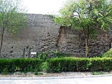
The Great Wall of China is one of the largest manmade wonders of the world, comprising many different and irregular structures. We employed airborne Lidar to produce highly accurate digital...
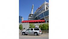
North American cities have been documented at speed using StreetMapper, using vehicle mounted laser scanners to capture highly detailed and accurate measurements at speed. The technique was developed and supplied...
This site uses cookies. By continuing to use this website, you agree to our Cookies Policy. Agree