Trimble Terra Office workflow links with Esri ArcGIS Pro
Trimble recently released the Trimble Terra Office add-in for Esri ArcGIS Pro. The add-in is a new product in the Terra Office suite of desktop solutions for integrating Trimble TerraFlex...
Trimble recently released the Trimble Terra Office add-in for Esri ArcGIS Pro. The add-in is a new product in the Terra Office suite of desktop solutions for integrating Trimble TerraFlex...

Trimble has announced the opening keynote speaker for its 2023 Trimble Dimensions Conference: Formula 1’s Mark Gallagher. The conference features three days of fast-paced education, innovation and networking with Trimble...
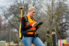
Woolpert has been contracted to collect high-density Lidar data for more than 17,500 square kilometres of rural Texas to map electrical distribution poles and wires along with surrounding natural and...
As the potential of geospatial data is unlocked, it’s more important than ever for you to connect and collaborate to drive the profession forward. GEO Business 2024 will host 120 global brands...
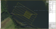
The EvoLogics Multibeam, a new multibeam echosounder option for the Sonobot 5 platform, was released at Ocean Business in Southampton, UK, in April this year. In May, EvoLogics conducted its final trials at one of the company’s regular testing sites the Plessower Lake in Brandenburg, Germany. The company is now taking the Sonobot 5 on a summer demonstration tour for partners and clients so that they can see its efficiency and effectiveness for underwater mapping for themselves. The EvoLogics Multibeam, a new multibeam echosounder option for the Sonobot 5 platform, was released at Ocean Business in Southampton, UK, in April this year. In May, EvoLogics conducted its...
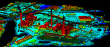
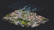
Aize, a provider of digital twin software for heavy-asset industries, and Cintoo, a provider of reality capture solutions, have announced a collaboration aimed at enhancing industry performance. Reality capture technologies...

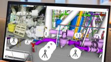
HxGN Smart Sites, a real-time data visualization and location intelligence solution for complex site operations such as industrial facilities, airports, hospitals and entertainment venues, has been announced by Hexagon’s Safety,...
Pix4D has introduced OPF, a new standard for exchanging photogrammetry projects. OPF is a fully open and free specification, enabling the storage and exchange of photogrammetric data among different parties...

GEO Business will put the spotlight on geospatial innovation for two days long, from 17-18 May. At ExCeL London, around 3,500 geospatial professionals will come together to discover and debate...

Population growth, urbanization and rapid digitalization all represent global challenges, but they also offer opportunities for the geospatial industry, because reality capture technology is an essential part of the puzzle...
This site uses cookies. By continuing to use this website, you agree to our Cookies Policy. Agree