SPAN MEMS Enclosed Receiver
NovAtel, headquartered in Canada, has added a single-enclosure SPAN MEMS receiver to its line of SPAN GNSS/INS products. Available in the first quarter of 2013, the low power, lightweight SPAN...
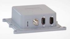
NovAtel, headquartered in Canada, has added a single-enclosure SPAN MEMS receiver to its line of SPAN GNSS/INS products. Available in the first quarter of 2013, the low power, lightweight SPAN...
OLinkStar has announced an integrated GNSS/MEMS Inertial Navigation System (INS) system, PNS100BGI. The system integrates GPS/ Compass /GLONASS, MEMS IMU, magnetometer, and barometer to deliver a reliable 3D navigation solution....
Xsens, headquartered in The Netherlands, has launched its new MTi product portfolio for industrial applications such as antenna/camera stabilisation and unmanned system control. With the introduction of this fourth-generation high-performance...
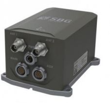
SBG Systems has launched the Apogee Series, an accurate inertial navigation system based on the robust and cost-effective MEMS technology. The Apogee Series is also the smallest and lightest inertial...
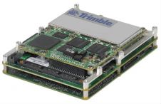
Trimble (USA) has added the AP20-C to its AP Series of embedded GNSS-Inertial OEM boards plus Inertial Measurement Unit (IMU). Using a compact, custom-built IMU based on commercial Micro Electromechanical...
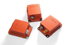
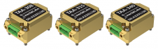
NovAtel has added four Micro Electromechanical Systems (MEMS) Inertial Measurement Units (IMUs) to its SPAN line of GNSS/INS products: the HG1900 and HG1930 IMUs from Honeywell International Inc. and the...
Inertial Labs has unveiled its latest innovation: high-precision three-axis accelerometers (TAA). These compact, self-contained devices mark a significant leap forward in navigation-grade accelerometers, promising unmatched precision in measuring linear accelerations....

Ordnance Survey, the national mapping agency for Great Britain, was in need of a faster and more cost-effective way to collect georeferenced point cloud data, because the existing method was not sustainable in the long term. The Ordnance Survey team turned to Datron Technology and OxTS to help them develop a convenient, low-cost, ‘off-the-shelf’ mobile mapping system. Ordnance Survey, the national mapping agency for Great Britain, was in need of a faster and more cost-effective way to collect georeferenced point cloud data, because the existing method was...
CHC Navigation is expanding its reach throughout Europe and the world, with more dealers and customer support and advanced training and service points. The Shanghai-based company has been a player in...

Innovations in Lidar technology continue to change the way we see our world – literally. There’s no denying that the Lidar sector is growing at an exponential rate. Research by...
This site uses cookies. By continuing to use this website, you agree to our Cookies Policy. Agree