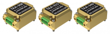
Found 62 results
Sort by

Ordnance Survey partners with OxTS

Ordnance Survey, the national mapping agency for Great Britain, was in need of a faster and more cost-effective way to collect georeferenced point cloud data, because the existing method was not sustainable in the long term. The Ordnance Survey team turned to Datron Technology and OxTS to help them develop a convenient, low-cost, ‘off-the-shelf’ mobile mapping system. Ordnance Survey, the national mapping agency for Great Britain, was in need of a faster and more cost-effective way to collect georeferenced point cloud data, because the existing method was...

Read more

CHC Navigation

CHC Navigation is expanding its reach throughout Europe and the world, with more dealers and customer support and advanced training and service points. The Shanghai-based company has been a player in...

Read more

Enabling UAV-Lidar to Fly Higher

Innovations in Lidar technology continue to change the way we see our world – literally. There’s no denying that the Lidar sector is growing at an exponential rate. Research by...

Read more

Satnav Watching over Rugby Players

As France’s top rugby players scrum, run and tackle they are being tracked by more than just TV cameras and the watching eyes of the crowd. Satnav-based tracking devices between...

Read more