Uncovering the competitive advantages of aerial surveying
What are the primary technical differences between crewed and uncrewed aerial vehicles and satellites when it comes to capturing images of Earth? Where do they overlap, and where do they...
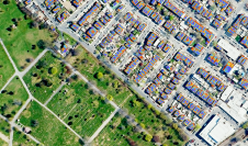
What are the primary technical differences between crewed and uncrewed aerial vehicles and satellites when it comes to capturing images of Earth? Where do they overlap, and where do they...

We asked James Kavanagh, head of land & resources with The Royal Institution of Chartered Surveyors (RICS), about the challenges facing the geospatial industry, the technological developments that will drive...

Do you ever stop to think about the ideas behind today’s geospatial technology? Many of them are thanks to methodologies and breakthroughs by our ancient counterparts, as this article explains. There is...

How can laser scanning and surveying firms stand out from the growing competition? This article provides tips for service providers striving to keep up with the latest technological trends while...

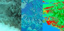
As AI increasingly becomes a vital element in today's mapping solutions, Wim van Wegen ponders its transformative power for our industry, and the prospect of it evolving into artificial consciousness...
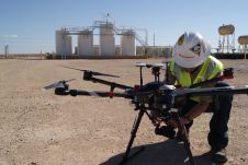
Field has announced its acquisition of PrecisionHawk, a US-based artificial intelligence (AI) and drone technology company for infrastructure management. With a premium client list of Fortune 500 companies, PrecisionHawk supports...
Russell Bollig and John Welter from Hexagon’s Geosystems division recently sat down with 'GIM International' to discuss the impact of AI on the geospatial industry. The conversation focused on hot...

At OxTS, in line with our brand promise of being inertial navigation experts, our commitment to our customers is that we will keep innovating until we can help them truly ‘navigate anywhere’ – with or without GNSS. We are advancing our products in that direction by first enhancing urban navigation data quality based on sensor fusion. Here, we explain how. At OxTS, in line with our brand promise of being inertial navigation experts, our commitment to our customers is that we will keep innovating until we can help them truly...

Bluesky Geospatial has announced the launch of its MetroVista 3D aerial mapping programme in the USA. The service employs a hybrid imaging-Lidar airborne sensor to capture highly detailed 3D data,...
In line with tradition, we have conducted the latest annual 'GIM International' survey among our readership of geospatial professionals to identify key trends, developments and challenges related to technology and business...
This site uses cookies. By continuing to use this website, you agree to our Cookies Policy. Agree