Future of Mining Americas 2018
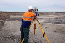
What is the current status of surveying in the mining industry, and which types of survey equipment and technologies are being used today? Geospatial data forms the foundation of mining....

With basic features like 2,500m range, 5mm accuracy and up to 500,000 measurements/sec and its new future-oriented, innovative processing architecture, internet connectivity, and RIEGL’s latest waveform processing Lidar technology, the VZ-2000i is...
Hexagon Mining has unveiled Stope Optimizer, a strategic mine planning tool for underground. It automates the design of stope shapes for a range of stoping methods. Using constraints and design parameters,...
UK-based geospatial mapping specialist, GeoSLAM, has expanded its mining offering, building on its world-leading reputation in the sector to provide advanced underground mining solutions. The news follows the unveiling of...
A growing number of mining companies are employing unmanned aerial vehicles (UAVs). Equipped with digital cameras, such remote-controlled small aircraft generate high-resolution aerial imagery which can be further processed to...

RIEGL offers three easy-to-use and innovative apps for applications in open-cast mining: Monitoring App, DesignCompare App, and SlopeAngle App. They support users in their daily work, especially in critical situations.
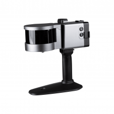
ComNav has announced the launch of its latest innovation: the LS300 3D laser scanner. This addition to the company's product lineup signifies a significant leap forward in addressing the dynamic...
Steven Vesterdal has a long and successful track record in the mining business. Steven has almost twelve years experience in modular mining systems where he worked as a project engineering...
GAF AG (Germany) has been awarded a contract to set-up a new computerised and countrywide mining cadastre system for Nigeria. After the successful completion of contract negotiations GAF has started...
This site uses cookies. By continuing to use this website, you agree to our Cookies Policy. Agree